SLOVAKIA 2008 -
BRATISLAVA, DANUBE BASIN AND CENTRAL HILLS:
Crossing the Slovak border close to
Bratislava, our first views of the capital city were not exactly
inspirational: approaching on the new motorway, the distant horizon
was sullied by the outline of the concrete forest of densely
populated tower-block housing estates of Petržalka where a third of
the city's 450,000 inhabitants live. Passing though the city on the
highway gave more attractive views of the Danube waterfront and old
town rising up as a backdrop to the garish shopping centres lining
the road.
Click on map for details
Avoiding the notoriously insecure
Zlaté Piesky Camping at Bratislava, we chose to camp at the small
town of Senec 15 kms to the east. Still bemused by unfamiliar
surroundings, we had our first
experience of Slovak food shopping at
a branch of the Austrian supermarket chain Billa which, along with
Tesco, seem to have a monopolistic hold in Slovakian towns. Slečné
Jazerá Camping set at the edge of Senec was crowded with Czech and
Slovaks here for holidays by the lakes. At any such location in
August, crowds were inevitable, but the atmosphere was good-natured,
and we found space among the tents. The campsite 'madame' was
hospitably welcoming and provided bus times and city maps for our
Bratislava visit. Boarding the bus in Senec, we tentatively used our
first Slovak, 'dva do (2 for) Bratislava autobusova stanica (bus
station)', proffering an unfamiliar 100 koruna (SKK) note. Passing
through the unattractive suburbs made the city no more appealing,
but with the 20 minute walk from the bus station to the Old Town (Staré
Mesto) fascination with our new surroundings began to remove the doubts.
The pedestrianised streets of the
old centre led past the attractive stara radnica (Old Town Hall)
with its restored Gothic and Renaissance buildings and coloured tile
roofs, and just beyond, we passed into the wide open square of
Hlavné námestie (Photo 1) lined with stalls and street
cafes. We spent a happy afternoon wandering among the restored
buildings of the Old Town: the Franciscan church and monastery, art
nouveau post office, Jesuit church gaudy as they generally are, and
convent of St Clara now the library of Bratislava university founded
in 1465 just before the invading barbarian Turks brought Hungary's
Renaissance beginnings to a premature close. Through the
delightfully shady Františkánske námestie, and past St Michael's
Tower which overtops the surviving gate into the old town, we walked
through narrow back streets and out into the modern city where
trams trundle by (Photo 2). This led up into the grounds
of Bratislava Castle, a megalithic square hilltop structure
overtopping the city, dating from 950 AD and aggrandised as a
Habsburg-Hungarian royal palace during the years when the Turks
occupied Buda. The view from the garden-terrace overlooks the
fast-flowing Danube with the single-column Nový Most (New Bridge)
(Photo 3)
immediately below. Beyond this, the vista southwards was dominated
by the vast Petržalka tower-block housing estates; forlorn though
this must be as a place to live, it was from this distance at least
a compelling sight. From the old city, we walked
down towards the river, past the Slovak National Theatre whose
ornate façade was gloriously lit by the afternoon sun. Back through
side streets, we found the Blue Church (Modrý Kostolík) (Photo
4), an art nouveau sky-blue wedding cake structure designed
around the turn of the 19/20th century and dedicated to Bratislava's
patron St Elizabeth. Wearily we plodded back to the bus
station to catch our evening bus back to camp at Senec and to
collapse with a cold Slovak beer. Despite Bratislava's much maligned
image compared with Prague, and the poor impression created from
passing the suburbs and tower blocks, it had proved a worthy city.
It's not as startling as Budapest nor even Zagreb; it's not as
endearing as Ljubljana, and fortunately not yet plagued by British
drunken louts on stag weekends, but the Old Town had proved
charming, and quite uncrowded even in August.
For useful background information
on visiting Bratislava and a city map, visit the
Bratislava Guide web site
Our first couple of days in
Slovakia had shown that very little English is spoken even by
youngsters, and that German is the most useful second language. More
importantly however, even a few words of spoken Slovak are really
appreciated, although it's more difficult than the South Slavic
languages.
Moving on, we began our tour of
Slovakia proper along the flatlands of the Danube (Dunaj) basin. The
fertile Podunajsko region produces the country's fruit, vegetables
and cereals and is home to the considerable ethnic Hungarian
population, as was clear from the dual-language road signs and
Magyar sounding village names. At Horný Bar the mighty River Danube
is canalised behind enormous leveés to form the Vodné dielo
Gabčikovo navigable waterway; this now drains off most of the
Danube's waters from its sluggish natural channel which forms the
Slovak-Hungarian border, to feed the controversial Gabčikovo
Hydro-electric Barrage. This monumental project to dam the Danube
and divert its waters was conceived in 1977 at the height of
the Communist period as a joint Czechoslovak-Hungarian venture.
Allegedly on environmental grounds, the Hungarian government in 1989
unilaterally withdrew from its commitment. Having invested so much
and desperate for alternative energy sources, the Czechoslovaks went
ahead with a scaled-down project. The two countries resorted to
legal wrangling
through the international court, which after several
years ruled unhelpfully that both countries were at fault, Hungary
for reneging on its agreement and Slovakia for diverting Danube
waters. The whole sorry mess is still unresolved, but the ecological
damage is done: the barrage exists spanning the waterway and
silently generating HEP. We followed the lines of pylons along back
lanes unsure of what we should encounter. The road led up across the
dam and we were able to watch one of the huge river boats passing
the massive locks of the Gabčikovo dam (Photo 5).
From the viewing platform, we could look across the width of the dam
towards the Hungarian bank.
From Gabčikovo we followed the Danube
down to Komárno, last visited by us in 2005 from the Hungarian side.
We could not resist a nostalgic re-crossing of the Danube bridge
border, created by the 1921 Treaty of Trianon which divides the
town. With a final Viszontlátásra
to Hungary, we re-crossed the now open-border to continue our
journey through Slovakia. Leaving behind the Danube flatlands, we
passed through Hurbanovo, home of the Zlatý Bažant (Golden Pheasant)
brewery which produces one of Slovakia's best-loved beers; started
in 1968 as a state enterprise, it is sadly now part of the dreaded
Heineken empire.
As we approached Nitra, the line of
hills rose up as a back-drop to the town; we should see little
further flatland during our time in Slovakia. Our campsite that
night was up into the hills just beyond the village of Jelenec; an
arrival we were greeted with a hillside of depressingly
semi-derelict huts and primitively basic facilities, but at least
the campsite was open and its bar served refreshingly chilled beer
at sensibly cheap prices - what more could you ask for? Before
moving on, we wanted to sample the colour-coded way-marked network
of walking paths which criss-cross Slovakia. Just outside Jelenec
Camping, the way-marked path led steeply upwards through oak and
beech woods whose shade brought welcome relief from the scorching
August sun. Gaining height steadily, with colour flashed way-marks
painted on trees, the ridge path led up to the extensive ruins of
Gýmeš Castle (Photo 6) which crowned the 518m high
hilltop. Re-assured by the constancy of the way-marks we
descended by a craggy alternative route back down through the woods.
Our onward route eastwards took us past the town of Levice with its
decidedly unattractive tower block estates (paneláky,
something we should come across in virtually every Slovak town), to
find our next campsite near the village of Kalinčikovo; what was
described incongruously by a well-known UK caravanning organisation
as a 'good family site' turned out to be a massive leisure complex,
seething with rowdy holiday-makers, and tonight - you lucky people -
it's disco night! Ah well, win some, lose some, and with a 460 SKK
nightly charge, ghastly surroundings, inadequate facilities and
high-volume disco, this was western materialism at its very worst.
Continuing eastwards over gloriously
wooded hill country, we descended to Zvolen, and a first class
campsite, Autocamping Neresnica, on the town's southern outskirts
and half hour walk from the centre. Zvolen is an important timber
logging centre and major rail transport junction (Photo 7).
Like so many Slovak towns, Zvolen's central square is named in
honour of the 1944 partisan Slovak National Uprising - the Slovenské
Narodné Povstanie (SNP). For most visitors the town's highlight is
its formidable-looking castle, but for us the important feature was
the railway station (Železnica stanica), a grandiose marble edifice
dating from the Communist era with an entrance hall the size of a
football pitch. Here we puzzled out the Byzantine mysteries of
Slovak railway timetables in order to visit nearby former mining
towns by the scenic railway lines. You can plan such rail journeys
in advance by entering
your start and destination stations and date of travel in the
Slovak National Railways web site
The first such journey was to visit
Banska Štiavnica tucked away among the wooded hills. The train winds
its way up the steep valley amid alpine pastures to reach the modern
part of the town with the Baroque old town a long walk uphill. The
town developed as a silver mining centre, the oldest mines dating
back to the 14th century. Skilled German miners were brought in to
work the seams and the resultant wealth can be seen in Banska
Štiavnica's grand houses, churches and monuments (Photo 8).
18th century water-pumping technology enabled deeper shafts to be
sunk, but with ore deposits exhausted, all of the mines are now
closed and a sad air of dereliction hangs over the town. One of the
adits, the 450m long Glazenberg Štôlna, tunnels 30m below the main
street and is open for visitors, kitted out in waterproofs, hard hat
and lamp, to get some appreciation of the hazardous working
conditions hewing out the hard silver ore. Wall plaques recall
earlier distinguished visitors. After our underground foray, and
walk around the town's former glory buildings, we made our way
back downhill, past the derelict factories and mine head-stocks, to
wait at the sadly neglected station for our train to trundle us back
down the rickety line to Zvolen.
Our second rail journey was to the
former gold-mining town of Kremnica. The skilfully engineered
single-track climbs over 460m in 14 kms up through thickly wooded
hills; Kremnica station, a classic of Slovak rural halts, is set
high above the town where the line contours around the hillside, and
a steep pathway (Staničný Chodnik) leads down into the town.
Kremnica's fame and wealth came from having the oldest continually
operating mint in Europe founded in 1328 and producing its renowned
ducats from Europe's richest gold mines. Kremnica gold kept the
medieval Hungarian kingdom's economy buoyant, and over the
centuries, 1000s of kilograms of gold have been produced. The Old
Town's grand houses, monuments and fortified church testify to
Kremnica's prosperity. The mines finally closed in the 1970s, but
the mint (Štátna mincovňa) still operates, now producing Euro coins
in readiness for Slovakia's adoption of the € in 2009; all round the
country, Euro-propaganda posters are softening up the population for
this dubious change. The steeply sloping, lawned and
tree-lined Štefánikovo námestie (central square) (Photo
9), with
Kremnica's monumental 18th century plague column (Photo 10) is overtopped by the
Gothic splendour of St Catherine's Church. 3 kms up the valley,
the hill village of Krahule is considered the geographical centre
of Europe.
Leaving Zvolen, we
headed north up the Hron valley to find the huge wooden church at
Hronsec built in 1726. By that time 90% of the Slovak peasantry was
Protestant, but the Jesuit-led Counter Reformation imposed ludicrous
restrictions on Protestant church building: outside village
boundary, no materials other than wood (not even nails), separate
bell-tower, and construction to be completed within one year.
Hronsec church complied with these articles, and its remarkable
survival is tribute to the craftsmen who built it. Its huge
cruciform nave and galleries with barrel-vaulted ceilings are
arranged as an amphitheatre around a central altar and can seat
1,100 worshippers; the church is still used for services every
Sunday, but standing under the huge lime trees, planted at
the time of the church's consecration, we wondered if such
congregations can be expected today.
Further up the river Hron, the town of
Banska Bystrica nestles between wooded hills, the brash commercial
buildings along its bypass and the unattractive paneláky of
tower blocks again detracting from the elegance of its old centre.
Banska Bystrica's wealth was also built on mining, this time copper
ore extracted from the hills around the town such as at the former
mining village of Špania Dolina. Auto-camping Tajov was our base for
visiting Banska Bystrica. Tucked away in a wooded side valley 6
kms west of the town, this campsite is a sheer delight: no English
is spoken but the family's welcoming hospitality speaks for itself
and the straightforward campsite is progressively being improved
including provision of free wi-fi internet access. The local bus
from Tajov takes 20 minutes into town, but the walk from the bus
station into the centre leads past the utterly tasteless area of
post-war Communist-inspired concrete four-square redevelopment
dominated by the Lux hotel, now ironically topped by a Coca-cola
sign. But a short distance further up Kapitalska ulica, the most
glorious expanse of town square opens up before you (Photo 11):
námestie
SNP
,
named in honour of the 1994 Slovak National Uprising, is surrounded
by beautifully restored medieval town houses and art nouveau
buildings, graced with fountains and flower beds and lined with
street cafes. One end of the square is dominated by a tall granite
obelisk commemorating Soviet troops killed in the liberation of Banska Bystrica in March 1945, and at
the top end you can climb the medieval Clock Tower for
magnificent views down the length of the square (Photo 12).
This we felt was one of the most pleasantly attractive urban spaces
in Europe. Banska Bystrica had been a key centre of the 1944 Slovak National
Uprising (SNP) and the town's other highlight is the SNP Museum and
the displays document the tragic history of the Uprising. It had
been timed to coincide with the Red Army's liberation of Slovakia
from the east, but this was delayed crossing the Carpathians from
Ukraine. The partisans were ruthlessly crushed by German forces and
the militia of Tiso's fascist puppet regime. Barbaric reprisals
followed with wholesale massacres of both partisans and civilians as
whole villages were razed. The post-war Communist regime made much
of the Uprising (every town has its námestie SNP), and although it
achieved little militarily and provoked savage reprisals, it did
serve to re-assert some sense of Slovak national pride after the
shame of the Tiso years. The Museum's displays of guns and uniforms
did little to impress, but the archive films and documentary
presentations (also in English) gave a balanced understanding of the
Uprising's importance for the Slovak nation. And after a welcome
beer in the square named in the SNP's honour, we caught our bus back
out to the rural tranquillity of Tajov Camping.
We continued east up the delightful
Hron valley following the line of the Low Tatras mountains. The road
passed the Panätnik Nemecka, a memorial to hundreds of local people from
nearby villages murdered in the post-SNP reprisal massacres. The
butchery of civilians was led by German officers, none of whom ever
faced justice for these crimes against humanity.
After a visit to the Bystrianska show
cave with its characteristic flow-stone formations hanging from
thick calcite crusts, and ride on the Čiernohronská
Železnica (Photo 13), a restored section of narrow-gauge logging railway which once brought timber down from the alpine forests, we reached
the small town of Brezno. Approached through the usual avenue of paneláky
tower blocks, the town nestles by the river Hron between the wooded
hills of the Low Tatras. And at the nearby village of Rohozná, we
reached what must be one of the most pleasant campsites in the whole
of Europe. Camping Sedliacky Dvor is run by a Dutch family who
swapped urban life in Holland for this idyllic rural setting in
central Slovakia. Their hospitality knows no bounds and sets a
standard which many other Slovak campsites would do well to follow;
the small campsite in a shady orchard behind their house looks out
over the rolling meadows of the Low Tatras foothills. And in the
evening, we sat around the wood camp fire listening to Dion and
Monique's stories about overcoming Slovak bureaucracy to establish
the campsite. If you visit central Slovakia, you must stay here and
in the meantime for more information, visit the website of Camping Sedliacky Dvor
The following morning as the sun
burnt off mist from the hills, we set out walking the ridge
along the length of the valley (Photo 14) above the campsite. Gaining height up
the hillside, the panorama of the wide valley opened out before us,
lit by the morning sunshine. Beyond the ridge's 750m high point, we
could make out the hutted encampment and sheep pens of local alpine
shepherds who tend their flocks in these hills. A flock of some 300
sheep are herded into pens for milking three times a day. The
shepherds live up here in the hills with their flocks even during
the heavy snows of winter, and eke out an impoverished living
selling sheep cheese. We approached hesitantly not wishing to
intrude, but the shepherds beckoned us closer, amused at our
interest. Having taken our photos of Low Tatras alpine sheep
milking (Photo 15) against the backdrop of the distant
Low Tatras mountains, we waved farewell to continue along the ridge
and to return past farms along back lanes to our camp at Sedliacky Dvor
lit by golden evening sun light (Photo 16).
We have covered much ground and many experiences during our first
two weeks in Slovakia, and our level of Slovak language is
increasing but with much still to learn.; we have experienced a wide
spectrum of campsites, a few mediocre but most of them welcoming and
in delightful settings culminating with our stay at Sedliacky Dvor.
Next week we move on eastwards up into the higher Hron valley, down
to the caves of Slovakia's Karst region and to the eastern city of
Košice, and beyond to the unknown of Slovakia's east along the
Ukraine borderlands More in two weeks .... dovidenia until then.

 experience of Slovak food shopping at
a branch of the Austrian supermarket chain Billa which, along with
Tesco, seem to have a monopolistic hold in Slovakian towns. Slečné
Jazerá Camping set at the edge of Senec was crowded with Czech and
Slovaks here for holidays by the lakes. At any such location in
August, crowds were inevitable, but the atmosphere was good-natured,
and we found space among the tents. The campsite 'madame' was
hospitably welcoming and provided bus times and city maps for our
Bratislava visit. Boarding the bus in Senec, we tentatively used our
first Slovak, 'dva do (2 for) Bratislava autobusova stanica (bus
station)', proffering an unfamiliar 100 koruna (SKK) note. Passing
through the unattractive suburbs made the city no more appealing,
but with the 20 minute walk from the bus station to the Old Town (Staré
Mesto) fascination with our new surroundings began to remove the doubts.
experience of Slovak food shopping at
a branch of the Austrian supermarket chain Billa which, along with
Tesco, seem to have a monopolistic hold in Slovakian towns. Slečné
Jazerá Camping set at the edge of Senec was crowded with Czech and
Slovaks here for holidays by the lakes. At any such location in
August, crowds were inevitable, but the atmosphere was good-natured,
and we found space among the tents. The campsite 'madame' was
hospitably welcoming and provided bus times and city maps for our
Bratislava visit. Boarding the bus in Senec, we tentatively used our
first Slovak, 'dva do (2 for) Bratislava autobusova stanica (bus
station)', proffering an unfamiliar 100 koruna (SKK) note. Passing
through the unattractive suburbs made the city no more appealing,
but with the 20 minute walk from the bus station to the Old Town (Staré
Mesto) fascination with our new surroundings began to remove the doubts. buildings of the Old Town: the Franciscan church and monastery, art
nouveau post office, Jesuit church gaudy as they generally are, and
convent of St Clara now the library of Bratislava university founded
in 1465 just before the invading barbarian Turks brought Hungary's
Renaissance beginnings to a premature close. Through the
delightfully shady Františkánske námestie, and past St Michael's
Tower which overtops the surviving gate into the old town, we walked
through narrow back streets and out into the modern city where
trams trundle by (Photo 2). This led up into the grounds
of Bratislava Castle, a megalithic square hilltop structure
overtopping the city, dating from 950 AD and aggrandised as a
buildings of the Old Town: the Franciscan church and monastery, art
nouveau post office, Jesuit church gaudy as they generally are, and
convent of St Clara now the library of Bratislava university founded
in 1465 just before the invading barbarian Turks brought Hungary's
Renaissance beginnings to a premature close. Through the
delightfully shady Františkánske námestie, and past St Michael's
Tower which overtops the surviving gate into the old town, we walked
through narrow back streets and out into the modern city where
trams trundle by (Photo 2). This led up into the grounds
of Bratislava Castle, a megalithic square hilltop structure
overtopping the city, dating from 950 AD and aggrandised as a
 Habsburg-Hungarian royal palace during the years when the Turks
occupied Buda. The view from the garden-terrace overlooks the
fast-flowing Danube with the single-column Nový Most (New Bridge)
(Photo 3)
immediately below. Beyond this, the vista southwards was dominated
by the vast Petržalka tower-block housing estates; forlorn though
this must be as a place to live, it was from this distance at least
a compelling sight. From the old city, we walked
down towards the river, past the Slovak National Theatre whose
ornate façade was gloriously lit by the afternoon sun. Back through
side streets, we found the Blue Church (Modrý Kostolík) (Photo
4), an art nouveau sky-blue wedding cake structure designed
around the turn of the 19/20th century and dedicated to Bratislava's
patron St Elizabeth. Wearily we plodded back to the bus
station to catch our evening bus back to camp at Senec and to
collapse with a cold Slovak beer. Despite Bratislava's much maligned
image compared with Prague, and the poor impression created from
passing the suburbs and tower blocks, it had proved a worthy city.
It's not as startling as Budapest nor even Zagreb; it's not as
endearing as Ljubljana, and fortunately not yet plagued by British
drunken louts on stag weekends, but the Old Town had proved
charming, and quite uncrowded even in August.
Habsburg-Hungarian royal palace during the years when the Turks
occupied Buda. The view from the garden-terrace overlooks the
fast-flowing Danube with the single-column Nový Most (New Bridge)
(Photo 3)
immediately below. Beyond this, the vista southwards was dominated
by the vast Petržalka tower-block housing estates; forlorn though
this must be as a place to live, it was from this distance at least
a compelling sight. From the old city, we walked
down towards the river, past the Slovak National Theatre whose
ornate façade was gloriously lit by the afternoon sun. Back through
side streets, we found the Blue Church (Modrý Kostolík) (Photo
4), an art nouveau sky-blue wedding cake structure designed
around the turn of the 19/20th century and dedicated to Bratislava's
patron St Elizabeth. Wearily we plodded back to the bus
station to catch our evening bus back to camp at Senec and to
collapse with a cold Slovak beer. Despite Bratislava's much maligned
image compared with Prague, and the poor impression created from
passing the suburbs and tower blocks, it had proved a worthy city.
It's not as startling as Budapest nor even Zagreb; it's not as
endearing as Ljubljana, and fortunately not yet plagued by British
drunken louts on stag weekends, but the Old Town had proved
charming, and quite uncrowded even in August. Danube
is canalised behind enormous leveés to form the Vodné dielo
Gabčikovo navigable waterway; this now drains off most of the
Danube's waters from its sluggish natural channel which forms the
Slovak-Hungarian border, to feed the controversial Gabčikovo
Hydro-electric Barrage. This monumental project to dam the Danube
and divert its waters was conceived in 1977 at the height of
the Communist period as a joint Czechoslovak-Hungarian venture.
Allegedly on environmental grounds, the Hungarian government in 1989
unilaterally withdrew from its commitment. Having invested so much
and desperate for alternative energy sources, the Czechoslovaks went
ahead with a scaled-down project. The two countries resorted to
legal wrangling
Danube
is canalised behind enormous leveés to form the Vodné dielo
Gabčikovo navigable waterway; this now drains off most of the
Danube's waters from its sluggish natural channel which forms the
Slovak-Hungarian border, to feed the controversial Gabčikovo
Hydro-electric Barrage. This monumental project to dam the Danube
and divert its waters was conceived in 1977 at the height of
the Communist period as a joint Czechoslovak-Hungarian venture.
Allegedly on environmental grounds, the Hungarian government in 1989
unilaterally withdrew from its commitment. Having invested so much
and desperate for alternative energy sources, the Czechoslovaks went
ahead with a scaled-down project. The two countries resorted to
legal wrangling
 through the international court, which after several
years ruled unhelpfully that both countries were at fault, Hungary
for reneging on its agreement and Slovakia for diverting Danube
waters. The whole sorry mess is still unresolved, but the ecological
damage is done: the barrage exists spanning the waterway and
silently generating HEP. We followed the lines of pylons along back
lanes unsure of what we should encounter. The road led up across the
dam and we were able to watch one of the huge river boats passing
the massive locks of the Gabčikovo dam (Photo 5).
From the viewing platform, we could look across the width of the dam
towards the Hungarian bank.
through the international court, which after several
years ruled unhelpfully that both countries were at fault, Hungary
for reneging on its agreement and Slovakia for diverting Danube
waters. The whole sorry mess is still unresolved, but the ecological
damage is done: the barrage exists spanning the waterway and
silently generating HEP. We followed the lines of pylons along back
lanes unsure of what we should encounter. The road led up across the
dam and we were able to watch one of the huge river boats passing
the massive locks of the Gabčikovo dam (Photo 5).
From the viewing platform, we could look across the width of the dam
towards the Hungarian bank. the hills just beyond the village of Jelenec; an
arrival we were greeted with a hillside of depressingly
semi-derelict huts and primitively basic facilities, but at least
the campsite was open and its bar served refreshingly chilled beer
at sensibly cheap prices - what more could you ask for? Before
moving on, we wanted to sample the colour-coded way-marked network
of walking paths which criss-cross Slovakia. Just outside Jelenec
Camping, the way-marked path led steeply upwards through oak and
beech woods whose shade brought welcome relief from the scorching
August sun. Gaining height steadily, with colour flashed way-marks
painted on trees, the ridge path led up to the extensive ruins of
Gýmeš Castle (Photo 6) which crowned the 518m high
hilltop. Re-assured by the constancy of the way-marks we
descended by a craggy alternative route back down through the woods.
Our onward route eastwards took us past the town of Levice with its
decidedly unattractive tower block estates (paneláky,
something we should come across in virtually every Slovak town), to
find our next campsite near the village of Kalinčikovo; what was
described incongruously by a well-known UK caravanning organisation
as a 'good family site' turned out to be a massive leisure complex,
seething with rowdy holiday-makers, and tonight - you lucky people -
it's disco night! Ah well, win some, lose some, and with a 460 SKK
nightly charge, ghastly surroundings, inadequate facilities and
high-volume disco, this was western materialism at its very worst.
the hills just beyond the village of Jelenec; an
arrival we were greeted with a hillside of depressingly
semi-derelict huts and primitively basic facilities, but at least
the campsite was open and its bar served refreshingly chilled beer
at sensibly cheap prices - what more could you ask for? Before
moving on, we wanted to sample the colour-coded way-marked network
of walking paths which criss-cross Slovakia. Just outside Jelenec
Camping, the way-marked path led steeply upwards through oak and
beech woods whose shade brought welcome relief from the scorching
August sun. Gaining height steadily, with colour flashed way-marks
painted on trees, the ridge path led up to the extensive ruins of
Gýmeš Castle (Photo 6) which crowned the 518m high
hilltop. Re-assured by the constancy of the way-marks we
descended by a craggy alternative route back down through the woods.
Our onward route eastwards took us past the town of Levice with its
decidedly unattractive tower block estates (paneláky,
something we should come across in virtually every Slovak town), to
find our next campsite near the village of Kalinčikovo; what was
described incongruously by a well-known UK caravanning organisation
as a 'good family site' turned out to be a massive leisure complex,
seething with rowdy holiday-makers, and tonight - you lucky people -
it's disco night! Ah well, win some, lose some, and with a 460 SKK
nightly charge, ghastly surroundings, inadequate facilities and
high-volume disco, this was western materialism at its very worst.") Continuing eastwards over gloriously
wooded hill country, we descended to Zvolen, and a first class
campsite, Autocamping Neresnica, on the town's southern outskirts
and half hour walk from the centre. Zvolen is an important timber
logging centre and major rail transport junction (Photo 7).
Like so many Slovak towns, Zvolen's central square is named in
honour of the 1944 partisan Slovak National Uprising - the Slovenské
Narodné Povstanie (SNP). For most visitors the town's highlight is
its formidable-looking castle, but for us the important feature was
the railway station (Železnica stanica), a grandiose marble edifice
dating from the Communist era with an entrance hall the size of a
football pitch. Here we puzzled out the Byzantine mysteries of
Slovak railway timetables in order to visit nearby former mining
towns by the scenic railway lines. You can plan such rail journeys
in advance by entering
your start and destination stations and date of travel in the
Continuing eastwards over gloriously
wooded hill country, we descended to Zvolen, and a first class
campsite, Autocamping Neresnica, on the town's southern outskirts
and half hour walk from the centre. Zvolen is an important timber
logging centre and major rail transport junction (Photo 7).
Like so many Slovak towns, Zvolen's central square is named in
honour of the 1944 partisan Slovak National Uprising - the Slovenské
Narodné Povstanie (SNP). For most visitors the town's highlight is
its formidable-looking castle, but for us the important feature was
the railway station (Železnica stanica), a grandiose marble edifice
dating from the Communist era with an entrance hall the size of a
football pitch. Here we puzzled out the Byzantine mysteries of
Slovak railway timetables in order to visit nearby former mining
towns by the scenic railway lines. You can plan such rail journeys
in advance by entering
your start and destination stations and date of travel in the
 The first such journey was to visit
Banska Štiavnica tucked away among the wooded hills. The train winds
its way up the steep valley amid alpine pastures to reach the modern
part of the town with the Baroque old town a long walk uphill. The
town developed as a silver mining centre, the oldest mines dating
back to the 14th century. Skilled German miners were brought in to
work the seams and the resultant wealth can be seen in Banska
Štiavnica's grand houses, churches and monuments (Photo 8).
18th century water-pumping technology enabled deeper shafts to be
sunk, but with ore deposits exhausted, all of the mines are now
closed and a sad air of dereliction hangs over the town. One of the
adits, the 450m long Glazenberg Štôlna, tunnels 30m below the main
street and is open for visitors, kitted out in waterproofs, hard hat
and lamp, to get some appreciation of the hazardous working
conditions hewing out the hard silver ore. Wall plaques recall
earlier distinguished visitors. After our underground foray, and
walk around the town's former glory buildings, we made our way
back downhill, past the derelict factories and mine head-stocks, to
wait at the sadly neglected station for our train to trundle us back
down the rickety line to Zvolen.
The first such journey was to visit
Banska Štiavnica tucked away among the wooded hills. The train winds
its way up the steep valley amid alpine pastures to reach the modern
part of the town with the Baroque old town a long walk uphill. The
town developed as a silver mining centre, the oldest mines dating
back to the 14th century. Skilled German miners were brought in to
work the seams and the resultant wealth can be seen in Banska
Štiavnica's grand houses, churches and monuments (Photo 8).
18th century water-pumping technology enabled deeper shafts to be
sunk, but with ore deposits exhausted, all of the mines are now
closed and a sad air of dereliction hangs over the town. One of the
adits, the 450m long Glazenberg Štôlna, tunnels 30m below the main
street and is open for visitors, kitted out in waterproofs, hard hat
and lamp, to get some appreciation of the hazardous working
conditions hewing out the hard silver ore. Wall plaques recall
earlier distinguished visitors. After our underground foray, and
walk around the town's former glory buildings, we made our way
back downhill, past the derelict factories and mine head-stocks, to
wait at the sadly neglected station for our train to trundle us back
down the rickety line to Zvolen. Our second rail journey was to the
former gold-mining town of Kremnica. The skilfully engineered
single-track climbs over 460m in 14 kms up through thickly wooded
hills; Kremnica station, a classic of Slovak rural halts, is set
high above the town where the line contours around the hillside, and
a steep pathway (Staničný Chodnik) leads down into the town.
Kremnica's fame and wealth came from having the oldest continually
operating mint in Europe founded in 1328 and producing its renowned
ducats from Europe's richest gold mines. Kremnica gold kept the
medieval Hungarian kingdom's economy buoyant, and over the
centuries, 1000s of kilograms of gold have been produced. The Old
Town's grand houses, monuments and fortified church testify to
Kremnica's prosperity. The mines finally closed in the 1970s, but
the mint (Štátna mincovňa) still operates, now producing Euro coins
in readiness for Slovakia's adoption of the € in 2009; all round the
country, Euro-propaganda posters are softening up the population for
this dubious change. The steeply sloping, lawned and
tree-lined Štefánikovo námestie (central square) (Photo
9), with
Kremnica's monumental 18th century plague column (Photo 10) is overtopped by the
Gothic splendour of St Catherine's Church. 3 kms up the valley,
the hill village of Krahule is considered the geographical centre
of Europe.
Our second rail journey was to the
former gold-mining town of Kremnica. The skilfully engineered
single-track climbs over 460m in 14 kms up through thickly wooded
hills; Kremnica station, a classic of Slovak rural halts, is set
high above the town where the line contours around the hillside, and
a steep pathway (Staničný Chodnik) leads down into the town.
Kremnica's fame and wealth came from having the oldest continually
operating mint in Europe founded in 1328 and producing its renowned
ducats from Europe's richest gold mines. Kremnica gold kept the
medieval Hungarian kingdom's economy buoyant, and over the
centuries, 1000s of kilograms of gold have been produced. The Old
Town's grand houses, monuments and fortified church testify to
Kremnica's prosperity. The mines finally closed in the 1970s, but
the mint (Štátna mincovňa) still operates, now producing Euro coins
in readiness for Slovakia's adoption of the € in 2009; all round the
country, Euro-propaganda posters are softening up the population for
this dubious change. The steeply sloping, lawned and
tree-lined Štefánikovo námestie (central square) (Photo
9), with
Kremnica's monumental 18th century plague column (Photo 10) is overtopped by the
Gothic splendour of St Catherine's Church. 3 kms up the valley,
the hill village of Krahule is considered the geographical centre
of Europe.
 side valley 6
kms west of the town, this campsite is a sheer delight: no English
is spoken but the family's welcoming hospitality speaks for itself
and the straightforward campsite is progressively being improved
including provision of free wi-fi internet access. The local bus
from Tajov takes 20 minutes into town, but the walk from the bus
station into the centre leads past the utterly tasteless area of
post-war Communist-inspired concrete four-square redevelopment
dominated by the Lux hotel, now ironically topped by a Coca-cola
sign. But a short distance further up Kapitalska ulica, the most
glorious expanse of town square opens up before you (Photo 11):
námestie
SNP
,
named in honour of the 1994 Slovak National Uprising, is surrounded
by beautifully restored medieval town houses and art nouveau
buildings, graced with fountains and flower beds and lined with
street cafes. One end of the square is dominated by a
side valley 6
kms west of the town, this campsite is a sheer delight: no English
is spoken but the family's welcoming hospitality speaks for itself
and the straightforward campsite is progressively being improved
including provision of free wi-fi internet access. The local bus
from Tajov takes 20 minutes into town, but the walk from the bus
station into the centre leads past the utterly tasteless area of
post-war Communist-inspired concrete four-square redevelopment
dominated by the Lux hotel, now ironically topped by a Coca-cola
sign. But a short distance further up Kapitalska ulica, the most
glorious expanse of town square opens up before you (Photo 11):
námestie
SNP
,
named in honour of the 1994 Slovak National Uprising, is surrounded
by beautifully restored medieval town houses and art nouveau
buildings, graced with fountains and flower beds and lined with
street cafes. One end of the square is dominated by a tall granite
obelisk commemorating Soviet troops killed in the liberation of Banska Bystrica in March 1945, and at
the top end you can climb the medieval Clock Tower for
magnificent views down the length of the square (Photo 12).
This we felt was one of the most pleasantly attractive urban spaces
in Europe. Banska Bystrica had been a key centre of the 1944 Slovak National
Uprising (SNP) and the town's other highlight is the SNP Museum and
the displays document the tragic history of the Uprising. It had
been timed to coincide with the Red Army's liberation of Slovakia
from the east, but this was delayed crossing the Carpathians from
Ukraine. The partisans were ruthlessly crushed by German forces and
the militia of Tiso's fascist puppet regime. Barbaric reprisals
followed with wholesale massacres of both partisans and civilians as
whole villages were razed. The post-war Communist regime made much
of the Uprising (every town has its námestie SNP), and although it
achieved little militarily and provoked savage reprisals, it did
serve to re-assert some sense of Slovak national pride after the
shame of the Tiso years. The Museum's displays of guns and uniforms
did little to impress, but the archive films and documentary
presentations (also in English) gave a balanced understanding of the
Uprising's importance for the Slovak nation. And after a welcome
beer in the square named in the SNP's honour, we caught our bus back
out to the rural tranquillity of Tajov Camping.
tall granite
obelisk commemorating Soviet troops killed in the liberation of Banska Bystrica in March 1945, and at
the top end you can climb the medieval Clock Tower for
magnificent views down the length of the square (Photo 12).
This we felt was one of the most pleasantly attractive urban spaces
in Europe. Banska Bystrica had been a key centre of the 1944 Slovak National
Uprising (SNP) and the town's other highlight is the SNP Museum and
the displays document the tragic history of the Uprising. It had
been timed to coincide with the Red Army's liberation of Slovakia
from the east, but this was delayed crossing the Carpathians from
Ukraine. The partisans were ruthlessly crushed by German forces and
the militia of Tiso's fascist puppet regime. Barbaric reprisals
followed with wholesale massacres of both partisans and civilians as
whole villages were razed. The post-war Communist regime made much
of the Uprising (every town has its námestie SNP), and although it
achieved little militarily and provoked savage reprisals, it did
serve to re-assert some sense of Slovak national pride after the
shame of the Tiso years. The Museum's displays of guns and uniforms
did little to impress, but the archive films and documentary
presentations (also in English) gave a balanced understanding of the
Uprising's importance for the Slovak nation. And after a welcome
beer in the square named in the SNP's honour, we caught our bus back
out to the rural tranquillity of Tajov Camping.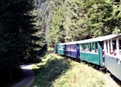 After a visit to the Bystrianska show
cave with its characteristic flow-stone formations hanging from
thick calcite crusts, and ride on the Čiernohronská
Železnica (Photo 13), a restored section of narrow-gauge logging railway which once brought timber down from the alpine forests, we reached
the small town of Brezno. Approached through the usual avenue of paneláky
tower blocks, the town nestles by the river Hron between the wooded
hills of the Low Tatras. And at the nearby village of Rohozná, we
reached what must be one of the most pleasant campsites in the whole
of Europe. Camping Sedliacky Dvor is run by a Dutch family who
swapped urban life in Holland for this idyllic rural setting in
central Slovakia. Their hospitality knows no bounds and sets a
standard which many other Slovak campsites would do well to follow;
the small campsite in a shady orchard behind their house looks out
over the rolling meadows of the Low Tatras foothills. And in the
evening, we sat around the wood camp fire listening to Dion and
Monique's stories about overcoming Slovak bureaucracy to establish
the campsite. If you visit central Slovakia, you must stay here and
in the meantime for more information, visit the
After a visit to the Bystrianska show
cave with its characteristic flow-stone formations hanging from
thick calcite crusts, and ride on the Čiernohronská
Železnica (Photo 13), a restored section of narrow-gauge logging railway which once brought timber down from the alpine forests, we reached
the small town of Brezno. Approached through the usual avenue of paneláky
tower blocks, the town nestles by the river Hron between the wooded
hills of the Low Tatras. And at the nearby village of Rohozná, we
reached what must be one of the most pleasant campsites in the whole
of Europe. Camping Sedliacky Dvor is run by a Dutch family who
swapped urban life in Holland for this idyllic rural setting in
central Slovakia. Their hospitality knows no bounds and sets a
standard which many other Slovak campsites would do well to follow;
the small campsite in a shady orchard behind their house looks out
over the rolling meadows of the Low Tatras foothills. And in the
evening, we sat around the wood camp fire listening to Dion and
Monique's stories about overcoming Slovak bureaucracy to establish
the campsite. If you visit central Slovakia, you must stay here and
in the meantime for more information, visit the  The following morning as the sun
burnt off mist from the hills, we set out walking the ridge
along the length of the valley (Photo 14) above the campsite. Gaining height up
the hillside, the panorama of the wide valley opened out before us,
lit by the morning sunshine. Beyond the ridge's 750m high point, we
could make out the hutted encampment and sheep pens of local alpine
shepherds who tend their flocks in these hills. A flock of some 300
sheep are herded into pens for milking three times a day. The
shepherds live up here in the hills with their flocks even during
the heavy snows of winter, and eke out an impoverished living
selling sheep cheese. We approached hesitantly not wishing to
intrude, but the shepherds beckoned us closer, amused at our
interest. Having taken our photos of Low Tatras alpine sheep
milking (Photo 15) against the backdrop of the distant
Low Tatras mountains, we waved farewell to continue along the ridge
and to return past farms along back lanes to our camp at Sedliacky Dvor
lit by golden evening sun light (Photo 16).
The following morning as the sun
burnt off mist from the hills, we set out walking the ridge
along the length of the valley (Photo 14) above the campsite. Gaining height up
the hillside, the panorama of the wide valley opened out before us,
lit by the morning sunshine. Beyond the ridge's 750m high point, we
could make out the hutted encampment and sheep pens of local alpine
shepherds who tend their flocks in these hills. A flock of some 300
sheep are herded into pens for milking three times a day. The
shepherds live up here in the hills with their flocks even during
the heavy snows of winter, and eke out an impoverished living
selling sheep cheese. We approached hesitantly not wishing to
intrude, but the shepherds beckoned us closer, amused at our
interest. Having taken our photos of Low Tatras alpine sheep
milking (Photo 15) against the backdrop of the distant
Low Tatras mountains, we waved farewell to continue along the ridge
and to return past farms along back lanes to our camp at Sedliacky Dvor
lit by golden evening sun light (Photo 16).
