CAMPING
IN POLAND 2010
- Baltic coast, Port-city of Gdańsk, Vistula Valley and Western Poland:
We drove from Frombork, on a combination of
ill-surfaced single-track lanes and newly constructed highway, to find another
remarkable piece of engineering dating from the days of East Prussia. The 81 km
Elbląg~Ostróda Canal, constructed in the mid-19th century to transport timber to
the Baltic ports, linked a series of natural lakes. The greatest technical
challenge facing the Prussian canal engineers was the 100m height difference to
be overcome in the first 10 km of canal between Elbląg on the coast and
the first lake near to Ostróda. The solution was an ingenious series
of 5 slipways or inclined planes, with boats off- and on-loaded to rail-bound
trolleys which were hauled by water-wheel operated cable-drums up/down the 500m
long sloping ramps, so raising boats an incredible 20m at each of the 5
slipways. 2 railed trolleys ran side by side at each ramp so that the weight of
a downward boat helped to haul the upward boat. Both the capital costs of
construction and the time taken for boats to pass up or down was far less than
that required by a conventional flight of locks, an altogether Germanically
efficient solution.
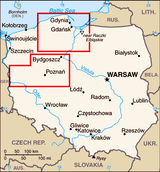
Click
on 2 regions of map for details of Northern and Western
Poland
Although
no longer used by freight traffic, the canal is still regularly travelled
by tourist boats, and we drove inland to see the inclined planes in action.
Although having little concept of what the inclined planes would look like or
their manner of operation, ahead of us along the towpath as we approached the
top end of the ramp, we could see 2 large wheels set cross-ways in the canal
with steel cables leading down into a winding house below the canal levée. The
cables connected underwater to a steel framework wheeled cradle onto which
a boat descending the slipway would be floated in the top basin. 2 sets of rails
emerged from the water, running over the upper lip of the inclined plane and
running down the 500m length at quite a steep angle into the lower basin where
the next section of canal began. The steel hawsers must have formed a continuous
loop between the top hauling wheels
and a similar set beyond the lower basin, rather like a ski lift, pulling a pair
of boats up and down the slope (Photo 1 - Elbląg Canal inclined plane and winding-gear).
We reached the next slipway, and were just examining the lower winding gear when
somewhere a bell rang, and the cables began to move; a boat was about to descend
the ramp. We sprinted back up the slope just as a tourist boat, set high on the
wheeled trolley, appeared over the brow to begin its downward passage. It was a
totally bizarre sight, as it passed the empty trolley moving up the slope, and
re-entered the water of the lower basin. Its engines re-started propelling the
boat
off the now submerged trolley, to resume its journey along the canal. The whole
passage from docking onto the top-trolley to sailing free in the lower basin
took no more than 15 minutes, an amazing piece of engineering apparatus (Photo 2 - Boat descending the inclined plane
and re-entering lower canal basin).
We camped that night at the delightfully
welcoming small riverside campsite at Elbląg just along from the town which had
suffered total destruction in the 1945 Red Army 'liberation'. Whereas other
Polish towns which had suffered similar destruction have long been restored, poor
sad little Elbląg seems to have languished under 50 years of desolation and the
tall gabled Prussian town houses are still in process of reconstruction.
Somehow the town seemed soulless, with just a few German tourists treading in
the path of the destruction brought about by their grandfathers. The view from
the top of the recently restored Gate-tower showed the scale of wartime damage
still to be cleared.
We moved on across the flatlands of the Vistula
estuary to reach the Baltic coastal village of Szututowo to visit the memorial
site of the Stutthof German WW2 concentration camp. Immediately following the
German invasion of Poland on 1 September 1939, massive roundups began of Poles
who were active in social, economic or political life; the population of the
free-city of Danzig was predominantly German and lists of members of Polish
cultural or nationalist organisations had been pre-assembled in readiness for
the invasion. In early September 1939, the first transports of Polish political
prisoners arrived at Stutthof; the forced labour and extermination camp served
the German purpose of eradicating
all Polish intelligentsia. In 1944 the camp was enlarged to become another mass
extermination centre contributing to the 'Final Solution to the Jewish
Question'. In total 110,000 victims were imprisoned at Stutthof from all across
Northern Europe of which 85,000 were murdered by physical exhaustion from slave
labour, malnutrition, brutality,
or infectious disease caused by overcrowding
and insanitary conditions. Gratifyingly after the war, the Polish authorities
tried a number of SS guards and kapos and many were executed including the camp
commandant. We entered the camp gates into the complex of surviving huts which
housed a museum on the camp's history and displays showing the horrific living
conditions (Photo 3 - the gates of Stutthof concentration camp).
At the far end of the electrified barbed-wire compound, we found the gas chamber
and crematoria, which contained further displays on the horrors of the forced
march evacuation of the camp in 1945 and the post-war trials of those
responsible for these crimes against humanity. Alongside the factories where
German companies had exploited the camp slave labour, the modern memorial was
inscribed with the words If man should grow silent, the very stones would cry
out. Visiting Polish school children looked bored as the guide explained to
them what had happened here; perhaps the stones should indeed cry out to ensure
that future
generations do remember German barbarity and the sufferings inflicted on so
many millions.
Just
beyond here, the Wiślana sand-spit peninsula extends for some 90 kms enclosing
the Wiślana Lagoon and divided at the halfway point by the border with the
Russian Oblast of Kaliningrad (see map left). A narrow road
runs along the
forested spit: part way along, we reached the backwater resort of Krynica Morska
mostly closed up in September, with its campsite on the gloomy pine-covered brow
of the peninsula. The following morning, we walked down to the northern side
of the sand-spit where the cold grey Baltic Sea washed onto the sandy beach. A
magnificent white strand stretched along the Baltic coastline in both directions
as far as the eye could see, but this was very much a working beach: down at the
water's edge, a small group of fishing boats were drawn up on the sand with
fishermen working around them. One of the fishermen was sat on a
pile of crates
gutting fish from last night's catch while others sorted nets
(Photo 4 - Krynica Morska fishing beach on Wiślana Sandspit). Gulls
flocked around to pounce greedily on the fish remains thrown into the water.
Another boat was beached and winched up onto the sand and visitors queued to buy
bags of fish straight from the deck
(Photo 5 - Selling the morning catch at Wiślana Sandspit fishing beach).
In the soft autumnal sunshine, this was a fascinating morning, and we treated
ourselves to a lunch of local fish at one of the beach cafés.
10
kms further along to the end of the narrow Wiślana peninsula's rough
single-track lane brought us finally to the tiny and isolated of Piaski the last
settlement before the sealed border with the Russian Oblast of Kaliningrad
divides the sand-spit. Leaving our camper in Piaski, we set off along the track
running through the pine woods over on the Baltic coast towards the Russian
border. After 4 kms, we reached the fence line marking the end of the EU
territory; entry beyond this point was forbidden. A short side path led over
dunes down onto the Baltic shoreline where the border fence continued down into the
water, and a 'Stop' sign reinforced the barrier. Along the beach into Russian
territory, we could see watch towers but no sign of any activity. On a sunny
autumn afternoon, the fence dividing this beautiful beach was a bizarre sight (Photo 6 - Polish~Russian (Kaliningrad) border
dividing the Wiślana Sandspit).
After a rest day camped in Piaski, we returned
along the peninsula and crossed the Vistula estuary fenlands heading towards
Gdańsk to find Camping Stogi in the city's eastern suburbs; from here we could
catch the #8 tram from its terminus at Stogi Plaża into the centre. The
following morning the tram dropped us at Brama Wyżynna to begin our 2 day visit.
As a major port-city, Gdańsk had developed as a leading member of the mercantile
Hanseatic League with Poland's grain and timber trade channelled through its
port. Merchants from across northern Europe were attracted to Gdańsk and Flemish
architects designed the tall gabled characteristic houses reflecting the
city's confidence and prosperity. Following the late 18th century Partitioning
of Poland, Gdańsk fell under Prussian control and after Poland's 1918
recovery of independence, under the post-WW1 Versailles Treaty Gdańsk
became the Free-City of Danzig acknowledging the city's predominantly German
population; Poland's access to the Baltic was assured by retention of the Polish
Corridor which separated Germany from East Prussia (see map right), a source of
outrage for Hitler and pretext for the 1939 invasion of Poland. The first shots
of WW2 were fired in Gdańsk with the German assault on the Polish
garrison at Westerplatte. In 1945 the Red Army inflicted total devastation on Gdańsk,
and after liberation the city was restored to Poland; the entire German
population was expelled and the city repopulated with Poles repatriated from the
Vilnius area of what became Soviet Lithuania. The devastated city was
meticulously restored so that today there is little evidence of wartime damage,
and the city's traditional shipping and ship-building industries revitalised. In the communist era, the
Gdańsk shipyards then known as the Lenin Shipyards became
the focus of popular discontent and protest against food shortages and price
increases during the 1970s~80s, leading to the formation of the eastern bloc's
first independent trade union Solidarność (Solidarity) under their charismatic
leader, shipyard electrician Lech Wałęsa. With free elections and
post-communism governments, Gdańsk blossomed again profiting from the increase
in tourism, but the shipyards which had been the focus of popular discontent
contributing to the downfall of communism have declined in the face of far east
competition; they remain an emotive and powerful symbol of today's Poland with
the Solidarity emblem seen everywhere albeit now more of a tourist attraction.
We
passed through the huge brick-built gateway of Brama Wyżynna into the Main
Town central area of Gdańsk with its iconic main thoroughfare, ulica Długa
(Long Street). This gave every appearance of a Hanseatic merchant city with its
tall, slender, gable-topped town houses; you could never have believed that the
city had been reduced to total devastation in 1945, so thorough had been the
post-war restoration (Photo 7 - Gdańsk's main thoroughfare, ulica Długa with the Town Hall).
Our first visit was to the Amber Museum (Museum Burstynu) whose fascinating
displays showed the formation of amber from 40 million year old fossilised pine
resin, the history of amber trade,
natural unpolished amber in its different
colours, and insects trapped in the pine resin lending semi-credence to the
Jurassic Park yarn (Photo 8 - Insect trapped
in amber displayed at Gdańsk Amber Museum).
The city Historical Museum in the Town Hall showed reconstructions of 1920s life
in the Free City of Danzig, but our interest was to climb to the top-terrace of
the tower for the panoramic views over the city roof tops with the
characteristic gable-topped façades. The view northwards towards the shipyards
cranes was blocked by the monumental bulk of St Mary's Church said to be the
world's largest brick-built church; photographs displayed in the Town Hall
showed the same view but telling the sorry story of the extent of wartime bomb
damage to the city (Photo
9 - Gdańsk cityscape panorama 2010 and the same scene showing 1945 wartime
devastation).
Returning
to ground level, we continued along Długi Targ past Gdańsk's famous
Neptune Fountain (Photo 10 - Neptune's Fountain and Arthur's Court in Gdańsk)
where street stalls selling amber jewellery, and the decorative façades of mercantile houses, to reach
the Waterfront. Along the waterside walk, buildings were
still in process of
restoration and on the far side of the Motława River
remaining areas of wartime damage were still visible. The waterfront lined with
cafés led to the restored 15th century Żuraw (Crane), 2 towers of the city
fortifications connected by a huge wooden structure extending out over the river,
housing the lifting gear of the medieval crane which was used for unloading
cargos from boats moored at the dockside and installing ship's masts. The
winding mechanism was operated by 2 pairs of massive wooden treadmills inside
which men 'pedalled' the crane (Photo 11 - Medieval restored wooden crane and winding mechanism at
Gdańsk Waterfront).
The Crane is part of Gdańsk's Maritime Museum housed in 3 former granaries
alongside the docks.
Having
devoted one day to the Gdańsk tourist trail, we wanted to devote our second
day to exploring the historic shipyards and their association with Solidarity
and the period of industrial protests which led ultimately to the downfall of
communism and emergence of the new democratic Poland in 1991. The tram dropped us close to Plac
Solidarnośći (Solidarity Square) next to the original Shipyard Gate Number 2 where in 1980 a young
Lech Wałęsa had made the historic announcement of the official
recognition of Solidarity as a trade union independent of Party control (Photo 12
- Gdańsk Shipyard Gates, scene of Solidarity protests).
Towering over the square were 3 enormous steel crosses, the Memorial to the
Fallen Shipyard Workers, commemorating the dozen demonstrating protesters killed
in 1970 when the dreaded ZOMO riot police opened fire on strikers protesting
against increased food prices and wage cuts as the incompetent communist regime
struggled to contain the mismanaged Polish economy (Photo 13 - Memorial at
Solidarity Square to Shipyard workers).
The dedicatory plaque declared that social disorder cannot be
contained by governmental force. Throughout the 1980s, the shipyards remained in the
forefront of political protest. The final strikes of 1989 led to the Round Table
Talks which forced the communists into power sharing and led eventually to the
first democratic elections and downfall of communism. The shipyard fence wall
alongside the square was lined with memorial plaques to the killed protesters
and a tablet recorded the famous 21 Demands of the 1980s strikers at the time of
Solidarity's recognition (Photo 14 - Memorial to Shipyard workers killed by riot police).
Standing here at this spot by the Gdańsk Shipyard gates was an evocatively
moving moment; this was the place where contemporary Poland began to take shape,
leading to the downfall of communism and all the terror and repression that had
kept it in power for 40 years, and the re-emergence of democratic government not
only in Poland but in all the other countries of the former eastern bloc.
Inside the shipyard gates, the area of what had once been dockland and shipyards
now seemed surprisingly empty, and hesitantly we walked towards the towering
cranes (Photo 15 - Gdańsk shipyards reduced to state of dereliction).
It was evident that the shipyards were now much reduced in scale and falling
into dereliction. Despite the economic boom of the 1990s, the shipyards by
then were unprofitable and on the verge of bankruptcy; only a wave of workers'
protests prevented the post-communist Polish government from closing
them
down. Attempts to modernise the yards and attract foreign investment collapsed
with the insistence that the full workforce be retained. Solidarity remained a
powerful political force, and successive Polish governments have been faced with
a dilemma: they could not appear hostile to the shipyards which remained a
popular symbol of Poland's re-emergence, and yet economic support for a
non-viable enterprise incurred EU criticism as illegal government subsidy. What
we witnessed today in the form of semi-dereliction, demolished infrastructure,
emptiness and any evidence of work activity seemed to confirm that the axe had
finally fallen on the once mighty Gdańsk shipyards, once the cradle of
Solidarity and origins of popular protest which progressively had brought down
communist control of central and eastern Europe - a sad but inevitable outcome.
If
you visit Gdańsk, spare time from the regular tourist route to visit 2
exhibitions near to the shipyards which will give insight into the momentous
events of the 1980s. The first is just inside the shipyard gates: Jest Jedna Solidarność
(There is One Solidarity) presents a collection of frantically moving
photographs and memorabilia of the protest movement during the last decade of
communism: the brutal suppression of the early waves of unrest by the ZOMO
security forces, the triumphant images of Lech Wałęsa as he announced
Solidarity's recognition, followed by the backlash by Jarulzelski's regime with martial law, Pope John-Paul II's support to the
protest movement, and finally the power sharing and first democratic elections.
The exhibition maintained by Solidarity is
clearly designed to emphasise the part played
by the trade union in both the 1970~80s and in contemporary Polish political
life, but is still a moving and wonderfully emotive celebration of Polish
resilience, epitomised by the unsmiling moustachioed figure of the charismatic
Solidarity leader Lech Wałęsa (see right) who went on to become
Poland's first post-communist president. Just around the corner the second
exhibition, Roads to Freedom is marked by the horrific symbol of the ZOMO
armoured troop-carrier parked outside, as seen on newsreel film firing on
protesters. This ultra-modern exhibition presents a multi-media record of the
terror and repression which kept the communists in power, the food shortages and
desperate living standards, the brief period of hope following Solidarity's
recognition dashed by Jarulzelski's imposition of martial law, and finally film clips showing the fall
of communism progressively in each of the former eastern bloc countries. This is
another enlightening, albeit horrific exhibition enlivened by contemporary
archive film, but essential to an understanding of how thankful the world should
be to those whose action and bravery helped to bring freedom to Eastern Europe.
Before
leaving Gdańsk, we drove out to Westerplatte on the outer eastern side of Gdańsk
harbour where the opening shots of WW2 were fired on 1 September 1939. Along
with the Polish Corridor to the west, the Poles had been allowed to maintain a
post at the tip of the Westerplatte peninsula which was later garrisoned as the
threat from Nazi Germany became more intense. The first shots of WW2 were fired
in Gdańsk when the German battleship Schleswig-Holstein, which was
on an alleged courtesy visit to Gdańsk harbour, turned its guns unannounced on the Polish
garrison at Westerplatte. The small Polish force
held out for a week against German bombardment until forced to
surrender. This spirited defence against overwhelming odds became symbolic of
the Poles determined but futile attempt to defend their homeland against the aggressive
combined might of Hitler's Germany and Stalin's USSR. The shelled guard-house of
the Polish barracks remains as left in 1939, and in the 1960s the communist
government of Poland erected an unsightly monument atop the hillock at Westerplatte; nearby are the graves of the Poles killed in the unprovoked
attack, and with these combined monuments the atmosphere of the place conveyed a sense of the
historic tragedy for Poland - 5 years of German aggression with cities left in
ruins and millions killed, followed by 40 years of communist repression.
We headed north-westwards to the Hel peninsula,
another lengthy sand-spit which encloses the Gulf of Gdańsk. The sand bar
was gradually formed over the course of 8,000 years by sea currents and
winds and is only 300m wide at its base near to Władysławowo (a resort town as
dreary as is its name is unpronounceable) and no wider than 500m for most of its
35 km of length. Only towards its tip at the tiny fishing port of Hel does the
sand spit expand to 3 km in width like an elongated tadpole. Most of the sandy
peninsula is covered by wind-stunted pine trees which anchor the dunes. Because
of its strategic position opposite the port of Gdańsk, the spit was heavily
fortified by the Poles in the late 1930s; Hel was the very last place in Poland
to surrender to the German invasion with Polish troops defending the town until
2 October 1939. The peninsula was again heavily fought over in 1945 when 60,000
German troops were eventually caught in a bottleneck in May 1945; Hel enjoys the
privilege of being the last piece of Polish territory to be liberated in 1945
and wartime devastation left the town in need of total rebuilding. After a
night's camp part-way along the sand-spit, we drove along to visit the little
fishing port with its main street lined by rows of 19th century single storey
fishermen's wooden cottages. The town's fishing fleet was anchored around the
quays of the harbour, with the fisherman unloading their catch and gutting the
fish (Photo 16 - Baltic coast fishing port on the Hel Peninsula).
Tempting smells of cooked fish wafted from a fish restaurant set alongside the
quay, and we celebrated our birthdays with a wonderful lunch of crisply fried
Baltic flat fish, flądra (pronounced flandra like the English flounder). After
lunch we just had to buy a brace of flądra straight from the boats for our
tomorrow's supper (Photo 17 - Buying flądra flatfish at Hel fishing port).
From the outer harbour wall, we stood watching cormorants skimming over the grey
Baltic Sea and terns swirling over the bay and diving for fish. Despite its
name, Hel had proved a delightful place, especially with its fried fish.
We
continued westwards along the northern Baltic coast, past Poland's most
northerly point at the chill, windswept Przylądek Rozewie lighthouse, where the
cold wind drove breakers against the shore. 60 kms further along the north
coast, we camped at Łeba using the hospitably welcoming and well-appointed
Camping Leśny. In summer Łeba would be
a place to avoid as a resort attracting hoards of German holiday-makers, but
fortunately in late September the town reverts to its other self as a quiet
little fishing port. Our reason for coming here was to visit the shifting sand
dunes of the Słowińsky National Park
which stretches 33 kms along the coast with 2 inland lagoons, trapped water from
a former coastal gulf enclosed by large depositions of sand which now form huge
dunes. The pine, oak and beech woods which once covered this sand bar are
gradually being eroded by the shifting dunes (Ruchome wydmy in Polish). Driven
by the constantly blowing wind, the dunes are moving up to 10m a year burying
everything in their path especially the trees, as in North Jutland in Denmark. The forest is progressively disappearing
under a sea of advancing sand to re-appear decades later as the skeletal stumps
of trees. The process began some 5,000 years ago and so far the dunes have
covered an area of 6 sq kms reaching a height of over 40m. For the shifting
dunes of Northern Jutland,
see
Our 2007 Danish travel log
From the National Park entrance at Rąbka just west
of Łeba, a track leads in 5 kms to the dunes, on the way passing the
rocket-testing launch pads which German scientists set up here in 1943~4
rivalling Peenemünde to develop Hitler's V-weapons. Deep in the forests which
cover the dunes, the Germans developed 2 rockets, the stumpy Rheintochter (Rhine
Daughter) which by rocket standards was a primitive device with limited speed
and range and soon superseded by the larger Rheinbote (Rhine Messenger), a sleek
11m long rocket, more sophisticated
and resembling the today's ground-to-air missiles. Despite some 80 test launches
here, neither of these rockets ever saw operational service, superseded by the
highly sophisticated V-weapons developed by Von Braun's team at Peenemünde; the
V2 achieved supersonic speed into space before plunging back earthwards with
devastating effect on London. The rocket test-site near to Łeba has a small
museum set in a former observation bunker showing technical details of the
rockets, replicas of which stood by one of the preserved concrete launch pads.
Alongside stood a modern Soviet missile developed doubtless by German scientists
captured by the Soviets just as the Americans had exploited the rocketry skills of
Von Braun; German wartime rocket technology was adopted by the Cold War
superpowers to bring the world to the brink of mutual destruction.
With
the glorious autumn sunlight streaming down through the tall pines, we walked
along towards the dunes. As the pines thinned, stunted dead trees projected from
the high walls of white sand (see left) and on the forest side the sand's line of advance
crept onwards down the slope enveloping more of the trees (see right). The path climbed the
slope of the Łacka Dune, 42m at its highest point, and the footprints in the
sand marked the passage of the 1000s of visitors attracted to this incredible
natural phenomenon. Ahead the Sahara-like dunes stretched away into the distant
west as far as the eye
could see; where the sand was undisturbed its
surface was surprisingly crisp consolidated by wind and rain (Photo 18 - Shifting sand dunes of Słowińsky National Park).
In the distance we could make out the lagoons now trapped inland by the 2 km
wide sand spit of dunes. It is said that Rommel's Afrika Korps exercised their
tanks here amid the dunes in preparation for the North African campaign. Towards
the coast, the Baltic Sea could just be seen over the line of dunes dotted with patches of scrub and marram grass (Photo
19 - Bleak dunes and marram grass at Słowińsky National Park).
A path led through onto a vast expanse of wild beach stretching away into the
distance in both directions, and the air was filled with the roar of the surf as
breakers crashed onto the sand at the water's edge (Photo 20 - Wild beaches along the
Baltic coast in Słowińsky
National Park).
Leaving Łeba
on another gloriously sunny autumn morning, we headed inland back towards Gdańsk
through the heartland of the Kashubians, a West Slavic people who speak a
dialect distantly related to Polish and have struggled to retain their ethnic
distinctiveness. The language was clearly enjoying a politically correct revival
judging by the dual language road signs, with Kashubian using every
conceivable accent on its vowels. In the small town of Kartuzy, an ethnographic
museum illustrated aspects of Kashubian rural life, with beautiful displays of
their distinctive embroidery.
The newly opened A1 motorway south from Gdańsk was almost empty with Poles
preferring the crowded older road rather than pay tolls; to us however, a toll
of 4.80zł (just over £1) to travel 40 miles seemed eminently more acceptable
compared with the extortionate tolls of French autoroutes. We turned off
crossing the wide River Wisła (Vistula) to Malbork, a town renowned for its 13th
century castle built by the Teutonic Knights. But our reason for coming here was
to find the Commonwealth War Graves Commission cemetery on the outskirts of the
town; here 53 WW1 British troops who had died in German
POW
camps in what was then East Prussia are buried or commemorated. The cemetery
also contains the graves of 232 British and Commonwealth WW2 dead, either those
who died in POW Camps in Poland or shot while escaping, or aircrew shot down on
long-range bombing or supply drop missions over Poland. We walked along the
neatly tended rows of graves to pay our respects to these men of the RAF and so
many British regiments who had died so far from home (Photo
21 - CWGC war cemetery at Malbork).
Just along the road was another WW2 cemetery, where the plaques recorded in
Cyrillic script the names of over 100 Red Army soldiers killed in the bitter
fighting to 'liberate' Malbork in the first 4 days of January 1945; Poland
exchanged one occupier for an arguably more repressive one for the next 45
years.
We
camped overnight at Malbork on the banks of the River Nogat in order to visit
the castle the following day. The Teutonic Knights, originally a religious
military order, served in the late 12th century Crusades but when in 1225 their
Saracen bashing came to an end, these redundant mercenaries had to find other
employment. Following an appeal from Duke Konrad of Mazuria for protection
against the predatory pagan Prussians, the Knights secured new employment in
these northern lands. Having annihilated the Prussian tribes, the Knights
adopted the name of Prussians for themselves, set up their base in a huge castle
at Malbork in the late 13th century and established themselves as the principal
military power in Northern Europe. Over the next century the Knights
additionally built up their political and economic power with control of the
Hanseatic cities and the timber and cereal trade, extending their territorial
control across the Baltic region. The Polish Crown realised its error in
allowing the Knights to gain such a foothold, and the showdown came in 1410 when
a combined Polish-Lithuanian army inflicted a major defeat on the Knights at the
Battle of Grunwald, an event which has attained legendary symbolism for Poles as
the major kick-in-the-teeth of the Germans. It has similarly never been
forgotten or forgiven in German folk memory, and one of Hitler's first vengeful
acts after the 1939 invasion was to destroy the Grunwald Memorial in Kraków. The
Knights were finally driven from their Malbork castle stronghold in 1457, and
withdrew
eastwards
to settle at Königsberg (modern Kaliningrad). In 1525 their Grand Master,
Albrecht von Hohenzollern, adopted the title of dukedom for East Prussia, and
although nominally paying homage to the Polish Crown, the Prussians had
autonomous control over their own affairs. Their conversion to Protestantism
gave the ruthlessly ambitious Hohenzollern clan a power base outside the control
of the Catholic Holy Roman Empire, a crucial step in determining future European
history. The 1795 Partitioning of Poland gave the Prussians control of north and
western Poland, and this power led in the mid-19th century to the welding of the
German states into a single nation under Prussian militaristic control. The
Kaisers were of Prussian Hohenzollern descent, leading the Germans into conquest
of southern Denmark and Alsace-Lorraine, and finally into WW1. And this power-mad
arrogant militarism all stemmed from the Teutonic Knights establishing their
base at the impregnable castle at Malbork.
The castle which dominates the town of Malbork had
grown over the centuries and had become a symbol of Prussian military might.
Like the town, the castle had been severely damaged during the Red Army's
battles to liberate the town, and in the
years since it has systematically been restored to its former scale and glory.
It is now a major tourist attraction, especially for the boatloads of Germans
visiting the seat of their arrogant ancestors' imperialist power. Well aware of
the tourist gold mine they are now sitting on, and bolstered by the acquisition
of UNESCO World Heritage status, the Poles now restrict visits to organised
tours which cost an arm and a leg; unless you are a military architectural
fanatic prepared to be ripped-off by commercial exploitation, then you would
best to do as we did and be content with photographing the castle's exterior
with a walk around its mighty walls and their Teutonic bulk (Photo
22 - Teutonic Knights' Castle at Malbork). You
really could not describe this ungainly pile of bricks as having any aesthetic
appeal
but somehow it personified the archetypal Teutonic militaristic ruthlessness.
Malbork itself is a non-descript place, but it
does have one curiosity which few of tourists actually see, tucked away in the
rather unkempt little park of Skwer Esperanto amid modern apartment blocks. The
name gives a clue to this oddly misplaced memorial to the late 19th century
originator of the artificial international language Esperanto, Ludwik Zamenhof.
A memorial to Doktoro Esperanto
(Dr
Hopeful) as Zamenhof came to be known stood in the centre of the park surrounded
by commemorative stones from Esperanto speakers all around the world. The
explanatory plaque was in Polish and Esperanto so we had no explanation as to
why the
incongruous memorial was here: neither Zamenhof nor the modern movement
associated with his international language have any connection with Malbork. He
was born of a Jewish family in Białystok then part of the Tsarist empire, and
accustomed to anti-Semitic bigotry from both Poles and Russians. An
ophthalmologist by training, Zamenhof dreamed that if he could devise a
universal language which all nations could speak, this would help the cause of
world peace and prevent racial prejudice. Esperanto was his life's achievement,
based on a root of the Romance languages and looking akin to Spanish. It
achieved a following mainly among academics but never the universal acceptance
that Zamenhof naively hoped for, and he died in 1917 at the height of WW1, the
greatest conflict in the history of human oppression. We were to have no
answer as to why his memorial stood in a scruffy park in Malbork, at least not
in a language we could understand, but in keeping with our tradition of pursuing
obscurities, it seemed a suitable subject to record.
On
a drearily grey, drizzly morning we headed south along the Vistula valley which
in its lower course is such a mightily wide waterway. Where the Łódź motorway
upgrade currently ends, we turned off to the hilltop town of Chełmno and wound
our way up into the old town. Chełmno first assumed importance when the
Teutonic Knights built a castle here in 1225 before their HQ at Malbork was
established; it continued to flourish as evidenced by the large Rynek, grand
Renaissance buildings like the Town Hall, the 3 kms circuit of surviving town
walls, but most particularly its monumental Gothic churches. Under the Prussian
Partition, Chełmno prospered as a small market town with its orderly grid
pattern of streets, and escaped WW2 damage and intrusive post-war industrial
development. In pouring rain, we spent an afternoon wandering around Chełmno's
grid of streets and its Renaissance Gothic churches, buying our supper
vegetables in the charming Rynek market (Photo
23 - Market day at Chełmno in the Vistula valley).
On the rear wall of the elaborately decorated Town Hall (see right) hung the
4.35m long 'Chełmno Rod', a medieval measuring stick used in the original
planning of the town's grid layout to ensure streets of similar width. The
Gothic interior of the recently renovated brick-built St Jacob's church was
elegantly plain, unlike the monumental Parish Church which was over-endowed with
ornate Baroque paraphernalia. One of the many altars was dedicated to St
Valentine with a casket containing one of the Lovers' Saint's relics; which particular
anatomical bit was not specified but it was only a little casket. In misty rain,
we continued down to Vistula valley, to camp on the banks of that mighty river
at Toruń, a town plagued by traffic on the main Route 1 which passes through the
middle of the town overwhelming the campsite with the
noise of heavy trucks.
Another mistily wet day, and we walked into the
town from gloomily unwelcoming Camping Tramp across the kilometre wide
girder-bridge which spans the River Wisła; it needed to be a strong bridge to
bear the weight of 3 lanes of stationery traffic queuing to cross.
Viewed from the Wisła bridge, the Gothic old town of Toruń looked grey and
gloomy this morning. The Teutonic Knights brought prosperity to Toruń
thanks to the Hanseatic river-borne trade with the Polish interior. This
economic boom found its expression in the mass of 13/14th century building
projects, particularly churches which still embellish the town today. Growing
disillusionment with the heavy burden of taxes which the Knights imposed on the
merchant classes brought their eventual ejection from Toruń. Royal
privileges and increased trade from all across Poland brought further wealth to
Toruń in the 16/17th
centuries, but the day of reckoning came with the 1795 Partitions: now under
Prussian control, the town lost its trade access to the Russian ruled hinterland
but despite being subjected to intense Germanisation, Toruń managed to
retain a strong Polish cultural associations. Post-WW1, the town returned to
Poland becoming part of the Polish Corridor which incensed Hitler's vengeful
rage after the 1939 invasion. Toruń managed to avoid damage in the Red Army
1945 'liberation', meaning that the buildings of its trading heyday survive for
visitors to see today. But the pouring rain gave little incentive for
sight-seeing, and after photographing the Rynek, we spent most of our day
visiting an institution associated with Toruń's other claim to fame as
being the 1473 birthplace of Nicolaus Copernicus, the Planetarium. The projected presentation focused on
Copernicus' radical helio-centric hypothesis, giving visual descriptions of the
planets and the solar system's place in the vast universe with an
imaginary space-time journey outwards into the infinite distance of the outer
galaxies. The showing ended with the pessimistic supposition that the universe
would ultimately end when the hydrogen fuel finally gave out; but don't worry,
the commentary added reassuringly, your grandchildren will be OK. We took
comfort from that and with the rain still pouring, we plodged back across the
Vistula bridge to the gloomy campsite.
Our
final day in Poland, we had the long drive down to Poznań so completing our
circuit of this vast country. Our plan was to camp tonight within reach of
the western border in readiness for starting tomorrow's homeward drive. There
was however time for one final visit as we passed Posnań. Just to the north of
the city, we knew of another curiosity which deserved our attention. Hidden away
in woodland between the villages of Morasko and Suchy Las, difficult to find
(GPS coordinates: N-52.489732,E-16.89723), is a set of meteorite impact craters
formed from debris falling some 3,500 years ago from the Perseid meteor shower
which passes the earth annually. The first of these meteorites was uncovered in
1914 by German soldiers digging fortifications. There are 7 craters, the largest
having a diameter of over 100m and 12m deep, and largest fragment of meteorite
found in 2006 weighs 164 kgms. The remains have been traced by metal detectors
because of the meteorites' high iron content and analysis has shown them to
contain silicates not found on earth. The original meteorite which created
this scale of impact crater must have been quite a chunk; the impact explosion
would have been pretty devastating and the craters now filled with water still
had earth banked up from the impact. So a trip which had been filled with so
much learning and fascinating new experiences concluded on this novel note,
photographing flooded craters from the impact of space debris 3,500 years ago (Photo
24 - Meteorite crater at Morasko). Late afternoon, in
unpleasantly busy traffic, we reached Route 2, truly having now come full circle
to reach the point we had started at on the day of our arrival in Poland 3½
months ago. Amid convoys of heavy trucks, and dodging the speed cameras, we
drove the final 80 kms to reach the trip's final campsite at Ostrów just 20 kms
short of the Polish~German border, ready to begin the long drive home towards
the Channel coast tomorrow.
This has been
one of our longer trips, yet despite almost 4 months and 4,200 miles travelled
within this vast country, there were still significant parts of Poland that we
had not managed to see. Of all our 13 major European ventures, this had probably
been the one which had produced the most by way of learning and discovery and
the most memorably moving recollections. We have stayed at 47 different campsites
within
Poland and western Lithuania: of these 3 have been in retrospect so laughably bad
as to merit our thumbs-down denunciation (2 of these still managed to retain
ACSI accreditation which just goes to show its utterly spurious value). More
worthily, 17 of the sites we used merited our highest ratings, and many of these
were delightful small, family-run campsites where the recollections of the
hospitality we received will linger on. In our final edition from Poland, to be
published in a couple of weeks, we shall as usual review all the campsites we
used, and along with this give our recommended Travel Tips, as an encouragement to others to visit
Poland. We met so many memorably interesting
people during our travels within Poland. It is now unbelievably 20 years since
that country was freed from the stifling repression and economic mismanagement
of the communist era. As with the other former Eastern Bloc countries we have
visited, what is so refreshing is to witness how the opportunities of this
new-found freedom have been used to advantage by this hard-working people. Of
course there are losers as well as winners, but despite our probing and
observance, we saw little evidence of overt poverty such as might have been
expected. If one word however can sum up our remembrance of the admirable Polish
nation, that word has to be resilience, a virtue that has helped to conserve
their language, culture and civilisation over centuries of oppression, not least
under the unspeakable evils which they suffered during the 5 years of barbaric German
occupation from 1939~45, and the 45 years of Soviet-dictated rule from 1945
until 1990. To the Polish people, we express the warmest dziękuję bardzo for
all the hospitality we have received during our stay in your country over the
last 4 months.
Sheila and Paul
Published: Sunday 7 November 2010
Final edition
reviewing Polish campsites to be published in 2 weeks

 CAMPING
IN POLAND 2010
- Baltic coast, Port-city of Gdańsk, Vistula Valley and Western Poland:
CAMPING
IN POLAND 2010
- Baltic coast, Port-city of Gdańsk, Vistula Valley and Western Poland: Although
no longer used by freight traffic, the canal is still regularly travelled
by tourist boats, and we drove inland to see the inclined planes in action.
Although having little concept of what the inclined planes would look like or
their manner of operation, ahead of us along the towpath as we approached the
top end of the ramp, we could see 2 large wheels set cross-ways in the canal
with steel cables leading down into a winding house below the canal levée. The
cables connected underwater to a steel framework wheeled cradle onto which
a boat descending the slipway would be floated in the top basin. 2 sets of rails
emerged from the water, running over the upper lip of the inclined plane and
running down the 500m length at quite a steep angle into the lower basin where
the next section of canal began. The steel hawsers must have formed a continuous
loop between the top hauling wheels
Although
no longer used by freight traffic, the canal is still regularly travelled
by tourist boats, and we drove inland to see the inclined planes in action.
Although having little concept of what the inclined planes would look like or
their manner of operation, ahead of us along the towpath as we approached the
top end of the ramp, we could see 2 large wheels set cross-ways in the canal
with steel cables leading down into a winding house below the canal levée. The
cables connected underwater to a steel framework wheeled cradle onto which
a boat descending the slipway would be floated in the top basin. 2 sets of rails
emerged from the water, running over the upper lip of the inclined plane and
running down the 500m length at quite a steep angle into the lower basin where
the next section of canal began. The steel hawsers must have formed a continuous
loop between the top hauling wheels and a similar set beyond the lower basin, rather like a ski lift, pulling a pair
of boats up and down the slope (Photo 1 - Elbląg Canal inclined plane and winding-gear).
We reached the next slipway, and were just examining the lower winding gear when
somewhere a bell rang, and the cables began to move; a boat was about to descend
the ramp. We sprinted back up the slope just as a tourist boat, set high on the
wheeled trolley, appeared over the brow to begin its downward passage. It was a
totally bizarre sight, as it passed the empty trolley moving up the slope, and
re-entered the water of the lower basin. Its engines re-started propelling the
and a similar set beyond the lower basin, rather like a ski lift, pulling a pair
of boats up and down the slope (Photo 1 - Elbląg Canal inclined plane and winding-gear).
We reached the next slipway, and were just examining the lower winding gear when
somewhere a bell rang, and the cables began to move; a boat was about to descend
the ramp. We sprinted back up the slope just as a tourist boat, set high on the
wheeled trolley, appeared over the brow to begin its downward passage. It was a
totally bizarre sight, as it passed the empty trolley moving up the slope, and
re-entered the water of the lower basin. Its engines re-started propelling the
 boat
off the now submerged trolley, to resume its journey along the canal. The whole
passage from docking onto the top-trolley to sailing free in the lower basin
took no more than 15 minutes, an amazing piece of engineering apparatus (Photo 2 - Boat descending the inclined plane
and re-entering lower canal basin).
boat
off the now submerged trolley, to resume its journey along the canal. The whole
passage from docking onto the top-trolley to sailing free in the lower basin
took no more than 15 minutes, an amazing piece of engineering apparatus (Photo 2 - Boat descending the inclined plane
and re-entering lower canal basin).
 1939, massive roundups began of Poles
who were active in social, economic or political life; the population of the
free-city of Danzig was predominantly German and lists of members of Polish
cultural or nationalist organisations had been pre-assembled in readiness for
the invasion. In early September 1939, the first transports of Polish political
prisoners arrived at Stutthof; the forced labour and extermination camp served
the German purpose of eradicating
all Polish intelligentsia. In 1944 the camp was enlarged to become another mass
extermination centre contributing to the 'Final Solution to the Jewish
Question'. In total 110,000 victims were imprisoned at Stutthof from all across
Northern Europe of which 85,000 were murdered by physical exhaustion from slave
labour, malnutrition, brutality,
1939, massive roundups began of Poles
who were active in social, economic or political life; the population of the
free-city of Danzig was predominantly German and lists of members of Polish
cultural or nationalist organisations had been pre-assembled in readiness for
the invasion. In early September 1939, the first transports of Polish political
prisoners arrived at Stutthof; the forced labour and extermination camp served
the German purpose of eradicating
all Polish intelligentsia. In 1944 the camp was enlarged to become another mass
extermination centre contributing to the 'Final Solution to the Jewish
Question'. In total 110,000 victims were imprisoned at Stutthof from all across
Northern Europe of which 85,000 were murdered by physical exhaustion from slave
labour, malnutrition, brutality,
 or infectious disease caused by overcrowding
and insanitary conditions. Gratifyingly after the war, the Polish authorities
tried a number of SS guards and kapos and many were executed including the camp
commandant. We entered the camp gates into the complex of surviving huts which
housed a museum on the camp's history and displays showing the horrific living
conditions (Photo 3 - the gates of Stutthof concentration camp).
At the far end of the electrified barbed-wire compound, we found the gas chamber
and crematoria, which contained further displays on the horrors of the forced
march evacuation of the camp in 1945 and the post-war trials of those
responsible for these crimes against humanity. Alongside the factories where
German companies had exploited the camp slave labour, the modern memorial was
inscribed with the words If man should grow silent, the very stones would cry
out. Visiting Polish school children looked bored as the guide explained to
them what had happened here; perhaps the stones should indeed cry out to ensure
that future
generations do remember German barbarity and the sufferings inflicted on so
many millions.
or infectious disease caused by overcrowding
and insanitary conditions. Gratifyingly after the war, the Polish authorities
tried a number of SS guards and kapos and many were executed including the camp
commandant. We entered the camp gates into the complex of surviving huts which
housed a museum on the camp's history and displays showing the horrific living
conditions (Photo 3 - the gates of Stutthof concentration camp).
At the far end of the electrified barbed-wire compound, we found the gas chamber
and crematoria, which contained further displays on the horrors of the forced
march evacuation of the camp in 1945 and the post-war trials of those
responsible for these crimes against humanity. Alongside the factories where
German companies had exploited the camp slave labour, the modern memorial was
inscribed with the words If man should grow silent, the very stones would cry
out. Visiting Polish school children looked bored as the guide explained to
them what had happened here; perhaps the stones should indeed cry out to ensure
that future
generations do remember German barbarity and the sufferings inflicted on so
many millions.
 runs along the
forested spit: part way along, we reached the backwater resort of Krynica Morska
mostly closed up in September, with its campsite on the gloomy pine-covered brow
of the peninsula. The following morning, we walked down to the northern side
of the sand-spit where the cold grey Baltic Sea washed onto the sandy beach. A
magnificent white strand stretched along the Baltic coastline in both directions
as far as the eye could see, but this was very much a working beach: down at the
water's edge, a small group of fishing boats were drawn up on the sand with
fishermen working around them. One of the fishermen was sat on a
runs along the
forested spit: part way along, we reached the backwater resort of Krynica Morska
mostly closed up in September, with its campsite on the gloomy pine-covered brow
of the peninsula. The following morning, we walked down to the northern side
of the sand-spit where the cold grey Baltic Sea washed onto the sandy beach. A
magnificent white strand stretched along the Baltic coastline in both directions
as far as the eye could see, but this was very much a working beach: down at the
water's edge, a small group of fishing boats were drawn up on the sand with
fishermen working around them. One of the fishermen was sat on a pile of crates
gutting fish from last night's catch while others sorted nets
(Photo 4 - Krynica Morska fishing beach on Wiślana Sandspit). Gulls
flocked around to pounce greedily on the fish remains thrown into the water.
Another boat was beached and winched up onto the sand and visitors queued to buy
bags of fish straight from the deck
(Photo 5 - Selling the morning catch at Wiślana Sandspit fishing beach).
In the soft autumnal sunshine, this was a fascinating morning, and we treated
ourselves to a lunch of local fish at one of the beach cafés.
pile of crates
gutting fish from last night's catch while others sorted nets
(Photo 4 - Krynica Morska fishing beach on Wiślana Sandspit). Gulls
flocked around to pounce greedily on the fish remains thrown into the water.
Another boat was beached and winched up onto the sand and visitors queued to buy
bags of fish straight from the deck
(Photo 5 - Selling the morning catch at Wiślana Sandspit fishing beach).
In the soft autumnal sunshine, this was a fascinating morning, and we treated
ourselves to a lunch of local fish at one of the beach cafés. 10
kms further along to the end of the narrow Wiślana peninsula's rough
single-track lane brought us finally to the tiny and isolated of Piaski the last
settlement before the sealed border with the Russian Oblast of Kaliningrad
divides the sand-spit. Leaving our camper in Piaski, we set off along the track
running through the pine woods over on the Baltic coast towards the Russian
border. After 4 kms, we reached the fence line marking the end of the EU
territory; entry beyond this point was forbidden. A short side path led over
dunes down onto the Baltic shoreline where the border fence continued down into the
water, and a 'Stop' sign reinforced the barrier. Along the beach into Russian
territory, we could see watch towers but no sign of any activity. On a sunny
autumn afternoon, the fence dividing this beautiful beach was a bizarre sight (Photo 6 - Polish~Russian (Kaliningrad) border
dividing the Wiślana Sandspit).
10
kms further along to the end of the narrow Wiślana peninsula's rough
single-track lane brought us finally to the tiny and isolated of Piaski the last
settlement before the sealed border with the Russian Oblast of Kaliningrad
divides the sand-spit. Leaving our camper in Piaski, we set off along the track
running through the pine woods over on the Baltic coast towards the Russian
border. After 4 kms, we reached the fence line marking the end of the EU
territory; entry beyond this point was forbidden. A short side path led over
dunes down onto the Baltic shoreline where the border fence continued down into the
water, and a 'Stop' sign reinforced the barrier. Along the beach into Russian
territory, we could see watch towers but no sign of any activity. On a sunny
autumn afternoon, the fence dividing this beautiful beach was a bizarre sight (Photo 6 - Polish~Russian (Kaliningrad) border
dividing the Wiślana Sandspit). following morning the tram dropped us at Brama Wyżynna to begin our 2 day visit.
As a major port-city, Gdańsk had developed as a leading member of the mercantile
Hanseatic League with Poland's grain and timber trade channelled through its
port. Merchants from across northern Europe were attracted to Gdańsk and Flemish
architects designed the tall gabled characteristic houses reflecting the
city's confidence and prosperity. Following the late 18th century Partitioning
of Poland, Gdańsk fell under Prussian control and after Poland's 1918
recovery of independence, under the post-WW1 Versailles Treaty Gdańsk
became the Free-City of Danzig acknowledging the city's predominantly German
population; Poland's access to the Baltic was assured by retention of the Polish
Corridor which separated Germany from East Prussia (see map right), a source of
outrage for Hitler and pretext for the 1939 invasion of Poland. The first shots
of WW2 were fired in Gdańsk with the German assault on the Polish
garrison at Westerplatte. In 1945 the Red Army inflicted total devastation on Gdańsk,
and after liberation the city was restored to Poland; the entire German
population was expelled and the city repopulated with Poles repatriated from the
Vilnius area of what became Soviet Lithuania. The devastated city was
following morning the tram dropped us at Brama Wyżynna to begin our 2 day visit.
As a major port-city, Gdańsk had developed as a leading member of the mercantile
Hanseatic League with Poland's grain and timber trade channelled through its
port. Merchants from across northern Europe were attracted to Gdańsk and Flemish
architects designed the tall gabled characteristic houses reflecting the
city's confidence and prosperity. Following the late 18th century Partitioning
of Poland, Gdańsk fell under Prussian control and after Poland's 1918
recovery of independence, under the post-WW1 Versailles Treaty Gdańsk
became the Free-City of Danzig acknowledging the city's predominantly German
population; Poland's access to the Baltic was assured by retention of the Polish
Corridor which separated Germany from East Prussia (see map right), a source of
outrage for Hitler and pretext for the 1939 invasion of Poland. The first shots
of WW2 were fired in Gdańsk with the German assault on the Polish
garrison at Westerplatte. In 1945 the Red Army inflicted total devastation on Gdańsk,
and after liberation the city was restored to Poland; the entire German
population was expelled and the city repopulated with Poles repatriated from the
Vilnius area of what became Soviet Lithuania. The devastated city was
, the eastern bloc's first independent trade union, founded in the Gdańsk shipyards") meticulously restored so that today there is little evidence of wartime damage,
and the city's traditional shipping and ship-building industries revitalised. In the communist era, the
Gdańsk shipyards then known as the Lenin Shipyards became
the focus of popular discontent and protest against food shortages and price
increases during the 1970s~80s, leading to the formation of the eastern bloc's
first independent trade union Solidarność (Solidarity) under their charismatic
leader, shipyard electrician Lech Wałęsa. With free elections and
post-communism governments, Gdańsk blossomed again profiting from the increase
in tourism, but the shipyards which had been the focus of popular discontent
contributing to the downfall of communism have declined in the face of far east
competition; they remain an emotive and powerful symbol of today's Poland with
the Solidarity emblem seen everywhere albeit now more of a tourist attraction.
meticulously restored so that today there is little evidence of wartime damage,
and the city's traditional shipping and ship-building industries revitalised. In the communist era, the
Gdańsk shipyards then known as the Lenin Shipyards became
the focus of popular discontent and protest against food shortages and price
increases during the 1970s~80s, leading to the formation of the eastern bloc's
first independent trade union Solidarność (Solidarity) under their charismatic
leader, shipyard electrician Lech Wałęsa. With free elections and
post-communism governments, Gdańsk blossomed again profiting from the increase
in tourism, but the shipyards which had been the focus of popular discontent
contributing to the downfall of communism have declined in the face of far east
competition; they remain an emotive and powerful symbol of today's Poland with
the Solidarity emblem seen everywhere albeit now more of a tourist attraction.") We
passed through the huge brick-built gateway of Brama Wyżynna into the Main
Town central area of Gdańsk with its iconic main thoroughfare, ulica Długa
(Long Street). This gave every appearance of a Hanseatic merchant city with its
tall, slender, gable-topped town houses; you could never have believed that the
city had been reduced to total devastation in 1945, so thorough had been the
post-war restoration (Photo 7 - Gdańsk's main thoroughfare, ulica Długa with the Town Hall).
Our first visit was to the Amber Museum (Museum Burstynu) whose fascinating
displays showed the formation of amber from 40 million year old fossilised pine
resin, the history of amber trade,
We
passed through the huge brick-built gateway of Brama Wyżynna into the Main
Town central area of Gdańsk with its iconic main thoroughfare, ulica Długa
(Long Street). This gave every appearance of a Hanseatic merchant city with its
tall, slender, gable-topped town houses; you could never have believed that the
city had been reduced to total devastation in 1945, so thorough had been the
post-war restoration (Photo 7 - Gdańsk's main thoroughfare, ulica Długa with the Town Hall).
Our first visit was to the Amber Museum (Museum Burstynu) whose fascinating
displays showed the formation of amber from 40 million year old fossilised pine
resin, the history of amber trade, natural unpolished amber in its different
colours, and insects trapped in the pine resin lending semi-credence to the
Jurassic Park yarn (Photo 8 - Insect trapped
in amber displayed at Gdańsk Amber Museum).
The city Historical Museum in the Town Hall showed reconstructions of 1920s life
in the Free City of Danzig, but our interest was to climb to the top-terrace of
the tower for the panoramic views over the city roof tops with the
characteristic gable-topped façades. The view northwards towards the shipyards
cranes was blocked by the monumental bulk of St Mary's Church said to be the
world's largest brick-built church; photographs displayed in the Town Hall
showed the same view but telling the sorry story of the extent of wartime bomb
damage to the city (Photo
9 - Gdańsk cityscape panorama 2010 and the same scene showing 1945 wartime
devastation).
natural unpolished amber in its different
colours, and insects trapped in the pine resin lending semi-credence to the
Jurassic Park yarn (Photo 8 - Insect trapped
in amber displayed at Gdańsk Amber Museum).
The city Historical Museum in the Town Hall showed reconstructions of 1920s life
in the Free City of Danzig, but our interest was to climb to the top-terrace of
the tower for the panoramic views over the city roof tops with the
characteristic gable-topped façades. The view northwards towards the shipyards
cranes was blocked by the monumental bulk of St Mary's Church said to be the
world's largest brick-built church; photographs displayed in the Town Hall
showed the same view but telling the sorry story of the extent of wartime bomb
damage to the city (Photo
9 - Gdańsk cityscape panorama 2010 and the same scene showing 1945 wartime
devastation).  Returning
to ground level, we continued along Długi Targ past Gdańsk's famous
Neptune Fountain (Photo 10 - Neptune's Fountain and Arthur's Court in Gdańsk)
where street stalls selling amber jewellery, and the decorative façades of mercantile houses, to reach
the Waterfront. Along the waterside walk, buildings were
still in process of
Returning
to ground level, we continued along Długi Targ past Gdańsk's famous
Neptune Fountain (Photo 10 - Neptune's Fountain and Arthur's Court in Gdańsk)
where street stalls selling amber jewellery, and the decorative façades of mercantile houses, to reach
the Waterfront. Along the waterside walk, buildings were
still in process of
 restoration and on the far side of the Motława River
remaining areas of wartime damage were still visible. The waterfront lined with
cafés led to the restored 15th century Żuraw (Crane), 2 towers of the city
fortifications connected by a huge wooden structure extending out over the river,
housing the lifting gear of the medieval crane which was used for unloading
cargos from boats moored at the dockside and installing ship's masts. The
winding mechanism was operated by 2 pairs of massive wooden treadmills inside
which men 'pedalled' the crane (Photo 11 - Medieval restored wooden crane and winding mechanism at
Gdańsk Waterfront).
The Crane is part of Gdańsk's Maritime Museum housed in 3 former granaries
alongside the docks.
restoration and on the far side of the Motława River
remaining areas of wartime damage were still visible. The waterfront lined with
cafés led to the restored 15th century Żuraw (Crane), 2 towers of the city
fortifications connected by a huge wooden structure extending out over the river,
housing the lifting gear of the medieval crane which was used for unloading
cargos from boats moored at the dockside and installing ship's masts. The
winding mechanism was operated by 2 pairs of massive wooden treadmills inside
which men 'pedalled' the crane (Photo 11 - Medieval restored wooden crane and winding mechanism at
Gdańsk Waterfront).
The Crane is part of Gdańsk's Maritime Museum housed in 3 former granaries
alongside the docks. Having
devoted one day to the Gdańsk tourist trail, we wanted to devote our second
day to exploring the historic shipyards and their association with Solidarity
and the period of industrial protests which led ultimately to the downfall of
communism and emergence of the new democratic Poland in 1991. The tram dropped us close to Plac
Solidarnośći (Solidarity Square) next to the original Shipyard Gate Number 2 where in 1980 a young
Lech Wałęsa had made the historic announcement of the official
recognition of Solidarity as a trade union independent of Party control (Photo 12
- Gdańsk Shipyard Gates, scene of Solidarity protests).
Towering over the square were 3 enormous steel crosses, the Memorial to the
Fallen Shipyard Workers, commemorating the dozen demonstrating protesters killed
in 1970 when the dreaded ZOMO riot police opened fire on strikers protesting
against increased food prices and wage cuts as the incompetent communist regime
struggled to contain the mismanaged Polish economy (Photo 13 - Memorial at
Solidarity Square to Shipyard workers).
The dedicatory plaque declared that social disorder cannot be
Having
devoted one day to the Gdańsk tourist trail, we wanted to devote our second
day to exploring the historic shipyards and their association with Solidarity
and the period of industrial protests which led ultimately to the downfall of
communism and emergence of the new democratic Poland in 1991. The tram dropped us close to Plac
Solidarnośći (Solidarity Square) next to the original Shipyard Gate Number 2 where in 1980 a young
Lech Wałęsa had made the historic announcement of the official
recognition of Solidarity as a trade union independent of Party control (Photo 12
- Gdańsk Shipyard Gates, scene of Solidarity protests).
Towering over the square were 3 enormous steel crosses, the Memorial to the
Fallen Shipyard Workers, commemorating the dozen demonstrating protesters killed
in 1970 when the dreaded ZOMO riot police opened fire on strikers protesting
against increased food prices and wage cuts as the incompetent communist regime
struggled to contain the mismanaged Polish economy (Photo 13 - Memorial at
Solidarity Square to Shipyard workers).
The dedicatory plaque declared that social disorder cannot be
 contained by governmental force. Throughout the 1980s, the shipyards remained in the
forefront of political protest. The final strikes of 1989 led to the Round Table
Talks which forced the communists into power sharing and led eventually to the
first democratic elections and downfall of communism. The shipyard fence wall
alongside the square was lined with memorial plaques to the killed protesters
and a tablet recorded the famous 21 Demands of the 1980s strikers at the time of
Solidarity's recognition (Photo 14 - Memorial to Shipyard workers killed by riot police).
Standing here at this spot by the Gdańsk Shipyard gates was an evocatively
moving moment; this was the place where contemporary Poland began to take shape,
leading to the downfall of communism and all the terror and repression that had
kept it in power for 40 years, and the re-emergence of democratic government not
only in Poland but in all the other countries of the former eastern bloc.
contained by governmental force. Throughout the 1980s, the shipyards remained in the
forefront of political protest. The final strikes of 1989 led to the Round Table
Talks which forced the communists into power sharing and led eventually to the
first democratic elections and downfall of communism. The shipyard fence wall
alongside the square was lined with memorial plaques to the killed protesters
and a tablet recorded the famous 21 Demands of the 1980s strikers at the time of
Solidarity's recognition (Photo 14 - Memorial to Shipyard workers killed by riot police).
Standing here at this spot by the Gdańsk Shipyard gates was an evocatively
moving moment; this was the place where contemporary Poland began to take shape,
leading to the downfall of communism and all the terror and repression that had
kept it in power for 40 years, and the re-emergence of democratic government not
only in Poland but in all the other countries of the former eastern bloc. Inside the shipyard gates, the area of what had once been dockland and shipyards
now seemed surprisingly empty, and hesitantly we walked towards the towering
cranes (Photo 15 - Gdańsk shipyards reduced to state of dereliction).
It was evident that the shipyards were now much reduced in scale and falling
into dereliction. Despite the economic boom of the 1990s, the shipyards by
then were unprofitable and on the verge of bankruptcy; only a wave of workers'
protests prevented the post-communist Polish government from closing
Inside the shipyard gates, the area of what had once been dockland and shipyards
now seemed surprisingly empty, and hesitantly we walked towards the towering
cranes (Photo 15 - Gdańsk shipyards reduced to state of dereliction).
It was evident that the shipyards were now much reduced in scale and falling
into dereliction. Despite the economic boom of the 1990s, the shipyards by
then were unprofitable and on the verge of bankruptcy; only a wave of workers'
protests prevented the post-communist Polish government from closing
 them
down. Attempts to modernise the yards and attract foreign investment collapsed
with the insistence that the full workforce be retained. Solidarity remained a
powerful political force, and successive Polish governments have been faced with
a dilemma: they could not appear hostile to the shipyards which remained a
popular symbol of Poland's re-emergence, and yet economic support for a
non-viable enterprise incurred EU criticism as illegal government subsidy. What
we witnessed today in the form of semi-dereliction, demolished infrastructure,
emptiness and any evidence of work activity seemed to confirm that the axe had
finally fallen on the once mighty Gdańsk shipyards, once the cradle of
Solidarity and origins of popular protest which progressively had brought down
communist control of central and eastern Europe - a sad but inevitable outcome.
them
down. Attempts to modernise the yards and attract foreign investment collapsed
with the insistence that the full workforce be retained. Solidarity remained a
powerful political force, and successive Polish governments have been faced with
a dilemma: they could not appear hostile to the shipyards which remained a
popular symbol of Poland's re-emergence, and yet economic support for a
non-viable enterprise incurred EU criticism as illegal government subsidy. What
we witnessed today in the form of semi-dereliction, demolished infrastructure,
emptiness and any evidence of work activity seemed to confirm that the axe had
finally fallen on the once mighty Gdańsk shipyards, once the cradle of
Solidarity and origins of popular protest which progressively had brought down
communist control of central and eastern Europe - a sad but inevitable outcome. If
you visit Gdańsk, spare time from the regular tourist route to visit 2
exhibitions near to the shipyards which will give insight into the momentous
events of the 1980s. The first is just inside the shipyard gates: Jest Jedna Solidarność
(There is One Solidarity) presents a collection of frantically moving
photographs and memorabilia of the protest movement during the last decade of
communism: the brutal suppression of the early waves of unrest by the ZOMO
security forces, the triumphant images of Lech Wałęsa as he announced
Solidarity's recognition, followed by the backlash by Jarulzelski's regime with martial law, Pope John-Paul II's support to the
protest movement, and finally the power sharing and first democratic elections.
The exhibition maintained by Solidarity is
clearly designed to emphasise the part
If
you visit Gdańsk, spare time from the regular tourist route to visit 2
exhibitions near to the shipyards which will give insight into the momentous
events of the 1980s. The first is just inside the shipyard gates: Jest Jedna Solidarność
(There is One Solidarity) presents a collection of frantically moving
photographs and memorabilia of the protest movement during the last decade of
communism: the brutal suppression of the early waves of unrest by the ZOMO
security forces, the triumphant images of Lech Wałęsa as he announced
Solidarity's recognition, followed by the backlash by Jarulzelski's regime with martial law, Pope John-Paul II's support to the
protest movement, and finally the power sharing and first democratic elections.
The exhibition maintained by Solidarity is
clearly designed to emphasise the part  played
by the trade union in both the 1970~80s and in contemporary Polish political
life, but is still a moving and wonderfully emotive celebration of Polish
resilience, epitomised by the unsmiling moustachioed figure of the charismatic
Solidarity leader Lech Wałęsa (see right) who went on to become
Poland's first post-communist president. Just around the corner the second
exhibition, Roads to Freedom is marked by the horrific symbol of the ZOMO
armoured troop-carrier parked outside, as seen on newsreel film firing on
protesters. This ultra-modern exhibition presents a multi-media record of the
terror and repression which kept the communists in power, the food shortages and
desperate living standards, the brief period of hope following Solidarity's
recognition dashed by Jarulzelski's imposition of martial law, and finally film clips showing the fall
of communism progressively in each of the former eastern bloc countries. This is
another enlightening, albeit horrific exhibition enlivened by contemporary
archive film, but essential to an understanding of how thankful the world should
be to those whose action and bravery helped to bring freedom to Eastern Europe.
played
by the trade union in both the 1970~80s and in contemporary Polish political
life, but is still a moving and wonderfully emotive celebration of Polish
resilience, epitomised by the unsmiling moustachioed figure of the charismatic
Solidarity leader Lech Wałęsa (see right) who went on to become
Poland's first post-communist president. Just around the corner the second
exhibition, Roads to Freedom is marked by the horrific symbol of the ZOMO
armoured troop-carrier parked outside, as seen on newsreel film firing on
protesters. This ultra-modern exhibition presents a multi-media record of the
terror and repression which kept the communists in power, the food shortages and
desperate living standards, the brief period of hope following Solidarity's
recognition dashed by Jarulzelski's imposition of martial law, and finally film clips showing the fall
of communism progressively in each of the former eastern bloc countries. This is
another enlightening, albeit horrific exhibition enlivened by contemporary
archive film, but essential to an understanding of how thankful the world should
be to those whose action and bravery helped to bring freedom to Eastern Europe. Before
leaving Gdańsk, we drove out to Westerplatte on the outer eastern side of Gdańsk
harbour where the opening shots of WW2 were fired on 1 September 1939. Along
with the Polish Corridor to the west, the Poles had been allowed to maintain a
post at the tip of the Westerplatte peninsula which was later garrisoned as the
threat from Nazi Germany became more intense. The first shots of WW2 were fired
in Gdańsk when the German battleship Schleswig-Holstein, which was
on an alleged courtesy visit to Gdańsk harbour, turned its guns unannounced on the Polish
garrison at Westerplatte. The small Polish
Before
leaving Gdańsk, we drove out to Westerplatte on the outer eastern side of Gdańsk
harbour where the opening shots of WW2 were fired on 1 September 1939. Along
with the Polish Corridor to the west, the Poles had been allowed to maintain a
post at the tip of the Westerplatte peninsula which was later garrisoned as the
threat from Nazi Germany became more intense. The first shots of WW2 were fired
in Gdańsk when the German battleship Schleswig-Holstein, which was
on an alleged courtesy visit to Gdańsk harbour, turned its guns unannounced on the Polish
garrison at Westerplatte. The small Polish  force
held out for a week against German bombardment until forced to
surrender. This spirited defence against overwhelming odds became symbolic of
the Poles determined but futile attempt to defend their homeland against the aggressive
combined might of Hitler's Germany and Stalin's USSR. The shelled guard-house of
the Polish barracks remains as left in 1939, and in the 1960s the communist
government of Poland erected an unsightly monument atop the hillock at Westerplatte; nearby are the graves of the Poles killed in the unprovoked
attack, and with these combined monuments the atmosphere of the place conveyed a sense of the
historic tragedy for Poland - 5 years of German aggression with cities left in
ruins and millions killed, followed by 40 years of communist repression.
force
held out for a week against German bombardment until forced to
surrender. This spirited defence against overwhelming odds became symbolic of
the Poles determined but futile attempt to defend their homeland against the aggressive
combined might of Hitler's Germany and Stalin's USSR. The shelled guard-house of
the Polish barracks remains as left in 1939, and in the 1960s the communist
government of Poland erected an unsightly monument atop the hillock at Westerplatte; nearby are the graves of the Poles killed in the unprovoked
attack, and with these combined monuments the atmosphere of the place conveyed a sense of the
historic tragedy for Poland - 5 years of German aggression with cities left in
ruins and millions killed, followed by 40 years of communist repression. Władysławowo (a resort town as
dreary as is its name is unpronounceable) and no wider than 500m for most of its
35 km of length. Only towards its tip at the tiny fishing port of Hel does the
sand spit expand to 3 km in width like an elongated tadpole. Most of the sandy
peninsula is covered by wind-stunted pine trees which anchor the dunes. Because
of its strategic position opposite the port of Gdańsk, the spit was heavily
fortified by the Poles in the late 1930s; Hel was the very last place in Poland
to surrender to the German invasion with Polish troops defending the town until
2 October 1939. The peninsula was again heavily fought over in 1945 when 60,000
German troops were eventually caught in a bottleneck in May 1945; Hel enjoys the
privilege of being the last piece of Polish territory to be liberated in 1945
and wartime devastation left the town in need of total rebuilding. After a
night's camp part-way along the sand-spit, we drove along to visit the little
fishing port with its main street lined by rows of 1
Władysławowo (a resort town as
dreary as is its name is unpronounceable) and no wider than 500m for most of its
35 km of length. Only towards its tip at the tiny fishing port of Hel does the
sand spit expand to 3 km in width like an elongated tadpole. Most of the sandy
peninsula is covered by wind-stunted pine trees which anchor the dunes. Because
of its strategic position opposite the port of Gdańsk, the spit was heavily
fortified by the Poles in the late 1930s; Hel was the very last place in Poland
to surrender to the German invasion with Polish troops defending the town until
2 October 1939. The peninsula was again heavily fought over in 1945 when 60,000
German troops were eventually caught in a bottleneck in May 1945; Hel enjoys the
privilege of being the last piece of Polish territory to be liberated in 1945
and wartime devastation left the town in need of total rebuilding. After a
night's camp part-way along the sand-spit, we drove along to visit the little
fishing port with its main street lined by rows of 1 9th century single storey
fishermen's wooden cottages. The town's fishing fleet was anchored around the
quays of the harbour, with the fisherman unloading their catch and gutting the
fish (Photo 16 - Baltic coast fishing port on the Hel Peninsula).
Tempting smells of cooked fish wafted from a fish restaurant set alongside the
quay, and we celebrated our birthdays with a wonderful lunch of crisply fried
Baltic flat fish, flądra (pronounced flandra like the English flounder). After
lunch we just had to buy a brace of flądra straight from the boats for our
tomorrow's supper (Photo 17 - Buying flądra flatfish at Hel fishing port).
From the outer harbour wall, we stood watching cormorants skimming over the grey
Baltic Sea and terns swirling over the bay and diving for fish. Despite its
name, Hel had proved a delightful place, especially with its fried fish.
9th century single storey
fishermen's wooden cottages. The town's fishing fleet was anchored around the
quays of the harbour, with the fisherman unloading their catch and gutting the
fish (Photo 16 - Baltic coast fishing port on the Hel Peninsula).
Tempting smells of cooked fish wafted from a fish restaurant set alongside the
quay, and we celebrated our birthdays with a wonderful lunch of crisply fried
Baltic flat fish, flądra (pronounced flandra like the English flounder). After
lunch we just had to buy a brace of flądra straight from the boats for our
tomorrow's supper (Photo 17 - Buying flądra flatfish at Hel fishing port).
From the outer harbour wall, we stood watching cormorants skimming over the grey
Baltic Sea and terns swirling over the bay and diving for fish. Despite its
name, Hel had proved a delightful place, especially with its fried fish. We
continued westwards along the northern Baltic coast, past Poland's most
northerly point at the chill, windswept Przylądek Rozewie lighthouse, where the
cold wind drove breakers against the shore. 60 kms further along the north
coast, we camped at Łeba using the hospitably welcoming and well-appointed
Camping Leśny. In summer Łeba would be
a place to avoid as a resort attracting hoards of German holiday-makers, but
fortunately in late September the town reverts to its other self as a quiet
little fishing port. Our reason for coming here was to visit the shifting sand
dunes of the Słowińsky National Park
which stretches 33 kms along the coast with 2 inland lagoons, trapped water from
a former coastal gulf enclosed by large depositions of sand which now form huge
dunes. The pine, oak and beech woods which once covered this sand bar are
gradually being eroded by the shifting dunes (Ruchome wydmy in Polish). Driven
by the constantly blowing wind, the dunes are moving up to 10m a year burying
everything in their path especially the trees, as in North Jutland in Denmark. The forest is progressively disappearing
under a sea of advancing sand to re-
We
continued westwards along the northern Baltic coast, past Poland's most
northerly point at the chill, windswept Przylądek Rozewie lighthouse, where the
cold wind drove breakers against the shore. 60 kms further along the north
coast, we camped at Łeba using the hospitably welcoming and well-appointed
Camping Leśny. In summer Łeba would be
a place to avoid as a resort attracting hoards of German holiday-makers, but
fortunately in late September the town reverts to its other self as a quiet
little fishing port. Our reason for coming here was to visit the shifting sand
dunes of the Słowińsky National Park
which stretches 33 kms along the coast with 2 inland lagoons, trapped water from
a former coastal gulf enclosed by large depositions of sand which now form huge
dunes. The pine, oak and beech woods which once covered this sand bar are
gradually being eroded by the shifting dunes (Ruchome wydmy in Polish). Driven
by the constantly blowing wind, the dunes are moving up to 10m a year burying
everything in their path especially the trees, as in North Jutland in Denmark. The forest is progressively disappearing
under a sea of advancing sand to re- appear decades later as the skeletal stumps
of trees. The process began some 5,000 years ago and so far the dunes have
covered an area of 6 sq kms reaching a height of over 40m. For the shifting
dunes of Northern Jutland,
see
appear decades later as the skeletal stumps
of trees. The process began some 5,000 years ago and so far the dunes have
covered an area of 6 sq kms reaching a height of over 40m. For the shifting
dunes of Northern Jutland,
see  WW2 rocket developed by German scientists at the Łeba rocket testing site") and resembling the today's ground-to-air missiles. Despite some 80 test launches
here, neither of these rockets ever saw operational service, superseded by the
highly sophisticated V-weapons developed by Von Braun's team at Peenemünde; the
V2 achieved supersonic speed into space before plunging back earthwards with
devastating effect on London. The rocket test-site near to Łeba has a small
museum set in a former observation bunker showing technical details of the
rockets, replicas of which stood by one of the preserved concrete launch pads.
Alongside stood a modern Soviet missile developed doubtless by German scientists
captured by the Soviets just as the Americans had exploited the rocketry skills of
Von Braun; German wartime rocket technology was adopted by the Cold War
superpowers to bring the world to the brink of mutual destruction.
and resembling the today's ground-to-air missiles. Despite some 80 test launches
here, neither of these rockets ever saw operational service, superseded by the
highly sophisticated V-weapons developed by Von Braun's team at Peenemünde; the
V2 achieved supersonic speed into space before plunging back earthwards with
devastating effect on London. The rocket test-site near to Łeba has a small
museum set in a former observation bunker showing technical details of the
rockets, replicas of which stood by one of the preserved concrete launch pads.
Alongside stood a modern Soviet missile developed doubtless by German scientists
captured by the Soviets just as the Americans had exploited the rocketry skills of
Von Braun; German wartime rocket technology was adopted by the Cold War
superpowers to bring the world to the brink of mutual destruction. With
the glorious autumn sunlight streaming down through the tall pines, we walked
along towards the dunes. As the pines thinned, stunted dead trees projected from
the high walls of white sand (see left) and on the forest side the sand's line of advance
crept onwards down the slope enveloping more of the trees (see right). The path climbed the
slope of the Łacka Dune, 42m at its highest point, and the footprints in the
sand marked the passage of the 1000s of visitors attracted to this incredible
natural phenomenon. Ahead the Sahara-like dunes stretched away into the distant
west as far as the eye
With
the glorious autumn sunlight streaming down through the tall pines, we walked
along towards the dunes. As the pines thinned, stunted dead trees projected from
the high walls of white sand (see left) and on the forest side the sand's line of advance
crept onwards down the slope enveloping more of the trees (see right). The path climbed the
slope of the Łacka Dune, 42m at its highest point, and the footprints in the
sand marked the passage of the 1000s of visitors attracted to this incredible
natural phenomenon. Ahead the Sahara-like dunes stretched away into the distant
west as far as the eye could see; where the sand was undisturbed its
surface was surprisingly crisp consolidated by wind and rain (Photo 18 - Shifting sand dunes of Słowińsky National Park).
In the distance we could make out the lagoons now trapped inland by the 2 km
wide sand spit of dunes. It is said that Rommel's Afrika Korps exercised their
tanks here amid the dunes in preparation for the North African campaign. Towards
the coast, the Baltic Sea could just be seen over the line of dunes dotted with patches of scrub and marram grass (Photo
19 - Bleak dunes and marram grass at Słowińsky National Park).
A path led through onto a vast expanse of wild beach stretching away into the
distance in both directions, and the air was filled with the roar of the surf as
breakers crashed onto the sand at the water's edge (Photo 20 - Wild beaches along the
Baltic coast in Słowińsky
National Park).
could see; where the sand was undisturbed its
surface was surprisingly crisp consolidated by wind and rain (Photo 18 - Shifting sand dunes of Słowińsky National Park).
In the distance we could make out the lagoons now trapped inland by the 2 km
wide sand spit of dunes. It is said that Rommel's Afrika Korps exercised their
tanks here amid the dunes in preparation for the North African campaign. Towards
the coast, the Baltic Sea could just be seen over the line of dunes dotted with patches of scrub and marram grass (Photo
19 - Bleak dunes and marram grass at Słowińsky National Park).
A path led through onto a vast expanse of wild beach stretching away into the
distance in both directions, and the air was filled with the roar of the surf as
breakers crashed onto the sand at the water's edge (Photo 20 - Wild beaches along the
Baltic coast in Słowińsky
National Park). Leaving Łeba
on another gloriously sunny autumn morning, we headed inland back towards Gdańsk
through the heartland of the Kashubians, a West Slavic people who speak a
dialect distantly related to Polish and have struggled to retain their ethnic
distinctiveness. The language was clearly enjoying a politically correct revival
judging by the dual language road signs, with Kashubian using every
conceivable accent on its vowels. In the small town of Kartuzy, an ethnographic
museum illustrated aspects of Kashubian rural life, with beautiful displays of
their distinctive embroidery.
Leaving Łeba
on another gloriously sunny autumn morning, we headed inland back towards Gdańsk
through the heartland of the Kashubians, a West Slavic people who speak a
dialect distantly related to Polish and have struggled to retain their ethnic
distinctiveness. The language was clearly enjoying a politically correct revival
judging by the dual language road signs, with Kashubian using every
conceivable accent on its vowels. In the small town of Kartuzy, an ethnographic
museum illustrated aspects of Kashubian rural life, with beautiful displays of
their distinctive embroidery. The newly opened A1 motorway south from Gdańsk was almost empty with Poles
preferring the crowded older road rather than pay tolls; to us however, a toll
of 4.80zł (just over £1) to travel 40 miles seemed eminently more acceptable
compared with the extortionate tolls of French autoroutes. We turned off
crossing the wide River Wisła (Vistula) to Malbork, a town renowned for its 13th
century castle built by the Teutonic Knights. But our reason for coming here was
to find the Commonwealth War Graves Commission cemetery on the outskirts of the
town; here 53 WW1 British troops who had died in German
The newly opened A1 motorway south from Gdańsk was almost empty with Poles
preferring the crowded older road rather than pay tolls; to us however, a toll
of 4.80zł (just over £1) to travel 40 miles seemed eminently more acceptable
compared with the extortionate tolls of French autoroutes. We turned off
crossing the wide River Wisła (Vistula) to Malbork, a town renowned for its 13th
century castle built by the Teutonic Knights. But our reason for coming here was
to find the Commonwealth War Graves Commission cemetery on the outskirts of the
town; here 53 WW1 British troops who had died in German
 POW
camps in what was then East Prussia are buried or commemorated. The cemetery
also contains the graves of 232 British and Commonwealth WW2 dead, either those
who died in POW Camps in Poland or shot while escaping, or aircrew shot down on
long-range bombing or supply drop missions over Poland. We walked along the
neatly tended rows of graves to pay our respects to these men of the RAF and so
many British regiments who had died so far from home (Photo
21 - CWGC war cemetery at Malbork).
Just along the road was another WW2 cemetery, where the plaques recorded in
Cyrillic script the names of over 100 Red Army soldiers killed in the bitter
fighting to 'liberate' Malbork in the first 4 days of January 1945; Poland
exchanged one occupier for an arguably more repressive one for the next 45
years.
POW
camps in what was then East Prussia are buried or commemorated. The cemetery
also contains the graves of 232 British and Commonwealth WW2 dead, either those
who died in POW Camps in Poland or shot while escaping, or aircrew shot down on
long-range bombing or supply drop missions over Poland. We walked along the
neatly tended rows of graves to pay our respects to these men of the RAF and so
many British regiments who had died so far from home (Photo
21 - CWGC war cemetery at Malbork).
Just along the road was another WW2 cemetery, where the plaques recorded in
Cyrillic script the names of over 100 Red Army soldiers killed in the bitter
fighting to 'liberate' Malbork in the first 4 days of January 1945; Poland
exchanged one occupier for an arguably more repressive one for the next 45
years. We
camped overnight at Malbork on the banks of the River Nogat in order to visit
the castle the following day. The Teutonic Knights, originally a religious
military order, served in the late 12th century Crusades but when in 1225 their
Saracen bashing came to an end, these redundant mercenaries had to find other
employment. Following an appeal from Duke Konrad of Mazuria for protection
against the predatory pagan Prussians, the Knights secured new employment in
these northern lands. Having annihilated the Prussian tribes, the Knights
adopted the name of Prussians for themselves, set up their base in a huge castle
at Malbork in the late 13th century and established themselves as the principal
military power in Northern Europe. Over the next century the Knights
additionally built up their political and economic power with control of the
Hanseatic cities and the timber and cereal trade, extending their territorial
control across the Baltic region. The Polish Crown realised its error in
allowing the Knights to gain such a foothold, and the showdown came in 1410 when
a combined Polish-Lithuanian army inflicted a major defeat on the Knights at the
Battle of Grunwald, an event which has attained legendary symbolism for Poles as
the major kick-in-the-teeth of the Germans. It has similarly never been
forgotten or forgiven in German folk memory, and one of Hitler's first vengeful
acts after the 1939 invasion was to destroy the Grunwald Memorial in Kraków. The
Knights were finally driven from their Malbork castle stronghold in 1457, and
withdrew
We
camped overnight at Malbork on the banks of the River Nogat in order to visit
the castle the following day. The Teutonic Knights, originally a religious
military order, served in the late 12th century Crusades but when in 1225 their
Saracen bashing came to an end, these redundant mercenaries had to find other
employment. Following an appeal from Duke Konrad of Mazuria for protection
against the predatory pagan Prussians, the Knights secured new employment in
these northern lands. Having annihilated the Prussian tribes, the Knights
adopted the name of Prussians for themselves, set up their base in a huge castle
at Malbork in the late 13th century and established themselves as the principal
military power in Northern Europe. Over the next century the Knights
additionally built up their political and economic power with control of the
Hanseatic cities and the timber and cereal trade, extending their territorial
control across the Baltic region. The Polish Crown realised its error in
allowing the Knights to gain such a foothold, and the showdown came in 1410 when
a combined Polish-Lithuanian army inflicted a major defeat on the Knights at the
Battle of Grunwald, an event which has attained legendary symbolism for Poles as
the major kick-in-the-teeth of the Germans. It has similarly never been
forgotten or forgiven in German folk memory, and one of Hitler's first vengeful
acts after the 1939 invasion was to destroy the Grunwald Memorial in Kraków. The
Knights were finally driven from their Malbork castle stronghold in 1457, and
withdrew
 eastwards
to settle at Königsberg (modern Kaliningrad). In 1525 their Grand Master,
Albrecht von Hohenzollern, adopted the title of dukedom for East Prussia, and
although nominally paying homage to the Polish Crown, the Prussians had
autonomous control over their own affairs. Their conversion to Protestantism
gave the ruthlessly ambitious Hohenzollern clan a power base outside the control
of the Catholic Holy Roman Empire, a crucial step in determining future European
history. The 1795 Partitioning of Poland gave the Prussians control of north and
western Poland, and this power led in the mid-19th century to the welding of the
German states into a single nation under Prussian militaristic control. The
Kaisers were of Prussian Hohenzollern descent, leading the Germans into conquest
of southern Denmark and Alsace-Lorraine, and finally into WW1. And this power-mad
arrogant militarism all stemmed from the Teutonic Knights establishing their
base at the impregnable castle at Malbork.
eastwards
to settle at Königsberg (modern Kaliningrad). In 1525 their Grand Master,
Albrecht von Hohenzollern, adopted the title of dukedom for East Prussia, and
although nominally paying homage to the Polish Crown, the Prussians had
autonomous control over their own affairs. Their conversion to Protestantism
gave the ruthlessly ambitious Hohenzollern clan a power base outside the control
of the Catholic Holy Roman Empire, a crucial step in determining future European
history. The 1795 Partitioning of Poland gave the Prussians control of north and
western Poland, and this power led in the mid-19th century to the welding of the
German states into a single nation under Prussian militaristic control. The
Kaisers were of Prussian Hohenzollern descent, leading the Germans into conquest
of southern Denmark and Alsace-Lorraine, and finally into WW1. And this power-mad
arrogant militarism all stemmed from the Teutonic Knights establishing their
base at the impregnable castle at Malbork.  years since it has systematically been restored to its former scale and glory.
It is now a major tourist attraction, especially for the boatloads of Germans
visiting the seat of their arrogant ancestors' imperialist power. Well aware of
the tourist gold mine they are now sitting on, and bolstered by the acquisition
of UNESCO World Heritage status, the Poles now restrict visits to organised
tours which cost an arm and a leg; unless you are a military architectural
fanatic prepared to be ripped-off by commercial exploitation, then you would
best to do as we did and be content with photographing the castle's exterior
with a walk around its mighty walls and their Teutonic bulk (Photo
22 - Teutonic Knights' Castle at Malbork). You
really could not describe this ungainly pile of bricks as having any aesthetic
appeal
but somehow it personified the archetypal Teutonic militaristic ruthlessness.
years since it has systematically been restored to its former scale and glory.
It is now a major tourist attraction, especially for the boatloads of Germans
visiting the seat of their arrogant ancestors' imperialist power. Well aware of
the tourist gold mine they are now sitting on, and bolstered by the acquisition
of UNESCO World Heritage status, the Poles now restrict visits to organised
tours which cost an arm and a leg; unless you are a military architectural
fanatic prepared to be ripped-off by commercial exploitation, then you would
best to do as we did and be content with photographing the castle's exterior
with a walk around its mighty walls and their Teutonic bulk (Photo
22 - Teutonic Knights' Castle at Malbork). You
really could not describe this ungainly pile of bricks as having any aesthetic
appeal
but somehow it personified the archetypal Teutonic militaristic ruthlessness. (Dr
Hopeful) as Zamenhof came to be known stood in the centre of the park surrounded
by commemorative stones from Esperanto speakers all around the world. The
explanatory plaque was in Polish and Esperanto so we had no explanation as to
why the
incongruous memorial was here: neither Zamenhof nor the modern movement
associated with his international language have any connection with Malbork. He
was born of a Jewish family in Białystok then part of the Tsarist empire, and
accustomed to anti-Semitic bigotry from both Poles and Russians. An
ophthalmologist by training, Zamenhof dreamed that if he could devise a
universal language which all nations could speak, this would help the cause of
world peace and prevent racial prejudice. Esperanto was his life's achievement,
based on a root of the Romance languages and looking akin to Spanish. It
achieved a following mainly among academics but never the universal acceptance
that Zamenhof naively hoped for, and he died in 1917 at the height of WW1, the
greatest conflict in the history of human oppression. We were to have no
answer as to why his memorial stood in a scruffy park in Malbork, at least not
in a language we could understand, but in keeping with our tradition of pursuing
obscurities, it seemed a suitable subject to record.
(Dr
Hopeful) as Zamenhof came to be known stood in the centre of the park surrounded
by commemorative stones from Esperanto speakers all around the world. The
explanatory plaque was in Polish and Esperanto so we had no explanation as to
why the
incongruous memorial was here: neither Zamenhof nor the modern movement
associated with his international language have any connection with Malbork. He
was born of a Jewish family in Białystok then part of the Tsarist empire, and
accustomed to anti-Semitic bigotry from both Poles and Russians. An
ophthalmologist by training, Zamenhof dreamed that if he could devise a
universal language which all nations could speak, this would help the cause of
world peace and prevent racial prejudice. Esperanto was his life's achievement,
based on a root of the Romance languages and looking akin to Spanish. It
achieved a following mainly among academics but never the universal acceptance
that Zamenhof naively hoped for, and he died in 1917 at the height of WW1, the
greatest conflict in the history of human oppression. We were to have no
answer as to why his memorial stood in a scruffy park in Malbork, at least not
in a language we could understand, but in keeping with our tradition of pursuing
obscurities, it seemed a suitable subject to record. On
a drearily grey, drizzly morning we headed south along the Vistula valley which
in its lower course is such a mightily wide waterway. Where the Łódź motorway
upgrade currently ends, we turned off to the hilltop town of Chełmno and wound
our way up into the old town. Chełmno first assumed importance when the
Teutonic Knights built a castle here in 1225 before their HQ at Malbork was
established; it continued to flourish as evidenced by the large Rynek, grand
Renaissance buildings like the Town Hall, the 3 kms circuit of surviving town
walls, but most particularly its monumental Gothic churches. Under the Prussian
Partition, Chełmno prospered as a small market town with its orderly grid
pattern of streets, and escaped WW2 damage and intrusive post-war industrial
development. In pouring rain, we spent an afternoon wandering around Chełmno's
grid of streets and its Renaissance Gothic churches, buying our supper
vegetables in the charming Rynek market (Photo
23 - Market day at Chełmno in the Vistula valley).
On the rear wall of the elaborately decorated Town Hall (see right) hung the
4.35m long 'Chełmno Rod', a medieval measuring stick used in the original
planning of the town's grid layout to ensure streets of similar width. The
Gothic interior of the recently renovated brick-built St Jacob's church was
elegantly plain, unlike the monumental Parish Church which was over-endowed with
ornate Baroque paraphernalia. One of the many altars was dedicated to St
Valentine with a casket containing one of the Lovers' Saint's relics; which particular
anatomical bit was not specified but it was only a little casket. In misty rain,
we continued down to Vistula valley, to camp on the banks of that mighty river
at Toruń, a town plagued by traffic on the main Route 1 which passes through the
middle of the town overwhelming the campsite with the
On
a drearily grey, drizzly morning we headed south along the Vistula valley which
in its lower course is such a mightily wide waterway. Where the Łódź motorway
upgrade currently ends, we turned off to the hilltop town of Chełmno and wound
our way up into the old town. Chełmno first assumed importance when the
Teutonic Knights built a castle here in 1225 before their HQ at Malbork was
established; it continued to flourish as evidenced by the large Rynek, grand
Renaissance buildings like the Town Hall, the 3 kms circuit of surviving town
walls, but most particularly its monumental Gothic churches. Under the Prussian
Partition, Chełmno prospered as a small market town with its orderly grid
pattern of streets, and escaped WW2 damage and intrusive post-war industrial
development. In pouring rain, we spent an afternoon wandering around Chełmno's
grid of streets and its Renaissance Gothic churches, buying our supper
vegetables in the charming Rynek market (Photo
23 - Market day at Chełmno in the Vistula valley).
On the rear wall of the elaborately decorated Town Hall (see right) hung the
4.35m long 'Chełmno Rod', a medieval measuring stick used in the original
planning of the town's grid layout to ensure streets of similar width. The
Gothic interior of the recently renovated brick-built St Jacob's church was
elegantly plain, unlike the monumental Parish Church which was over-endowed with
ornate Baroque paraphernalia. One of the many altars was dedicated to St
Valentine with a casket containing one of the Lovers' Saint's relics; which particular
anatomical bit was not specified but it was only a little casket. In misty rain,
we continued down to Vistula valley, to camp on the banks of that mighty river
at Toruń, a town plagued by traffic on the main Route 1 which passes through the
middle of the town overwhelming the campsite with the
 noise of heavy trucks.
 centuries, but the day of reckoning came with the 1795 Partitions: now under
Prussian control, the town lost its trade access to the Russian ruled hinterland
but despite being subjected to intense Germanisation, Toruń managed to
retain a strong Polish cultural associations. Post-WW1, the town returned to
Poland becoming part of the Polish Corridor which incensed Hitler's vengeful
rage after the 1939 invasion. Toruń managed to avoid damage in the Red Army
1945 'liberation', meaning that the buildings of its trading heyday survive for
visitors to see today. But the pouring rain gave little incentive for
sight-seeing, and after photographing the Rynek, we spent most of our day
visiting an institution associated with Toruń's other claim to fame as
being the 1473 birthplace of Nicolaus Copernicus, the Planetarium. The projected presentation focused on
Copernicus' radical helio-centric hypothesis, giving visual descriptions of the
planets and the solar system's place in the vast universe with an
imaginary space-time journey outwards into the infinite distance of the outer
galaxies. The showing ended with the pessimistic supposition that the universe
would ultimately end when the hydrogen fuel finally gave out; but don't worry,
the commentary added reassuringly, your grandchildren will be OK. We took
comfort from that and with the rain still pouring, we plodged back across the
Vistula bridge to the gloomy campsite.
centuries, but the day of reckoning came with the 1795 Partitions: now under
Prussian control, the town lost its trade access to the Russian ruled hinterland
but despite being subjected to intense Germanisation, Toruń managed to
retain a strong Polish cultural associations. Post-WW1, the town returned to
Poland becoming part of the Polish Corridor which incensed Hitler's vengeful
rage after the 1939 invasion. Toruń managed to avoid damage in the Red Army
1945 'liberation', meaning that the buildings of its trading heyday survive for
visitors to see today. But the pouring rain gave little incentive for
sight-seeing, and after photographing the Rynek, we spent most of our day
visiting an institution associated with Toruń's other claim to fame as
being the 1473 birthplace of Nicolaus Copernicus, the Planetarium. The projected presentation focused on
Copernicus' radical helio-centric hypothesis, giving visual descriptions of the
planets and the solar system's place in the vast universe with an
imaginary space-time journey outwards into the infinite distance of the outer
galaxies. The showing ended with the pessimistic supposition that the universe
would ultimately end when the hydrogen fuel finally gave out; but don't worry,
the commentary added reassuringly, your grandchildren will be OK. We took
comfort from that and with the rain still pouring, we plodged back across the
Vistula bridge to the gloomy campsite. Our
final day in Poland, we had the long drive down to Poznań so completing our
circuit of this vast country. Our plan was to camp tonight within reach of
the western border in readiness for starting tomorrow's homeward drive. There
was however time for one final visit as we passed Posnań. Just to the north of
the city, we knew of another curiosity which deserved our attention. Hidden away
in woodland between the villages of Morasko and Suchy Las, difficult to find
(GPS coordinates: N-52.489732,E-16.89723), is a set of meteorite impact craters
formed from debris falling some 3,500 years ago from the Perseid meteor shower
which passes the earth annually. The first of these meteorites was uncovered in
1914 by German soldiers digging fortifications. There are 7 craters, the largest
having a diameter of over 100m and 12m deep, and largest fragment of meteorite
found in 2006 weighs 164 kgms. The remains have been traced by metal detectors
because of the meteorites' high iron content and analysis has shown them to
contain silicates not found on earth. The original meteorite which created
Our
final day in Poland, we had the long drive down to Poznań so completing our
circuit of this vast country. Our plan was to camp tonight within reach of
the western border in readiness for starting tomorrow's homeward drive. There
was however time for one final visit as we passed Posnań. Just to the north of
the city, we knew of another curiosity which deserved our attention. Hidden away
in woodland between the villages of Morasko and Suchy Las, difficult to find
(GPS coordinates: N-52.489732,E-16.89723), is a set of meteorite impact craters
formed from debris falling some 3,500 years ago from the Perseid meteor shower
which passes the earth annually. The first of these meteorites was uncovered in
1914 by German soldiers digging fortifications. There are 7 craters, the largest
having a diameter of over 100m and 12m deep, and largest fragment of meteorite
found in 2006 weighs 164 kgms. The remains have been traced by metal detectors
because of the meteorites' high iron content and analysis has shown them to
contain silicates not found on earth. The original meteorite which created this scale of impact crater must have been quite a chunk; the impact explosion
would have been pretty devastating and the craters now filled with water still
had earth banked up from the impact. So a trip which had been filled with so
much learning and fascinating new experiences concluded on this novel note,
photographing flooded craters from the impact of space debris 3,500 years ago (Photo
24 - Meteorite crater at Morasko). Late afternoon, in
unpleasantly busy traffic, we reached Route 2, truly having now come full circle
to reach the point we had started at on the day of our arrival in Poland 3½
months ago. Amid convoys of heavy trucks, and dodging the speed cameras, we
drove the final 80 kms to reach the trip's final campsite at Ostrów just 20 kms
short of the Polish~German border, ready to begin the long drive home towards
the Channel coast tomorrow.
this scale of impact crater must have been quite a chunk; the impact explosion
would have been pretty devastating and the craters now filled with water still
had earth banked up from the impact. So a trip which had been filled with so
much learning and fascinating new experiences concluded on this novel note,
photographing flooded craters from the impact of space debris 3,500 years ago (Photo
24 - Meteorite crater at Morasko). Late afternoon, in
unpleasantly busy traffic, we reached Route 2, truly having now come full circle
to reach the point we had started at on the day of our arrival in Poland 3½
months ago. Amid convoys of heavy trucks, and dodging the speed cameras, we
drove the final 80 kms to reach the trip's final campsite at Ostrów just 20 kms
short of the Polish~German border, ready to begin the long drive home towards
the Channel coast tomorrow. within
Poland and western Lithuania: of these 3 have been in retrospect so laughably bad
as to merit our thumbs-down denunciation (2 of these still managed to retain
ACSI accreditation which just goes to show its utterly spurious value). More
worthily, 17 of the sites we used merited our highest ratings, and many of these
were delightful small, family-run campsites where the recollections of the
hospitality we received will linger on. In our final edition from Poland, to be
published in a couple of weeks, we shall as usual review all the campsites we
used, and along with this give our recommended Travel Tips, as an encouragement to others to visit
Poland. We met so many memorably interesting
within
Poland and western Lithuania: of these 3 have been in retrospect so laughably bad
as to merit our thumbs-down denunciation (2 of these still managed to retain
ACSI accreditation which just goes to show its utterly spurious value). More
worthily, 17 of the sites we used merited our highest ratings, and many of these
were delightful small, family-run campsites where the recollections of the
hospitality we received will linger on. In our final edition from Poland, to be
published in a couple of weeks, we shall as usual review all the campsites we
used, and along with this give our recommended Travel Tips, as an encouragement to others to visit
Poland. We met so many memorably interesting people during our travels within Poland. It is now unbelievably 20 years since
that country was freed
people during our travels within Poland. It is now unbelievably 20 years since
that country was freed 
